
A raster pyramid is a reduced-resolution version of a raster. The purpose of a pyramid is to reduce the time it takes to display a raster. Pyramids can be built at multiple levels to help strike a balance between the pyramid's file size and the display speed.
To build a raster overview in QGIS, click on Build overviews (Pyramids) by navigating to Raster | Miscellaneous. This will open the Build overviews (Pyramids) tool window, as shown in the following screenshot:
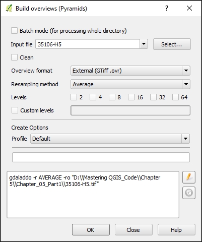
The Build overviews tool provides a few options, as well as the ability to edit the GDAL command that will build the overviews. By selecting Batch mode, an entire directory of rasters will be processed, instead of the default of a single raster. In either case, the following options are available:
- Input file: The raster (or directory of rasters) that will have overviews built.
- Clean: If this is selected, any previously built overviews will be deleted.
- Overview format: The format of the built overviews. The options are as follows:
- External (GTiff.ovr): In this format, the overviews are stored in the external
.ovrfile. The file will have the same base name as the original input file. - Internal (if possible): In this format, the overviews are stored within the raster file. Note that the Clean option will not remove previously built internal overviews.
- External (Erdas Imagine .aux): In this format, the overviews are stored in the external
.auxfile. The file will have the same base name as the original input file.
- External (GTiff.ovr): In this format, the overviews are stored in the external
- Resampling method: The resampling method used to downsample the input raster.
- Levels: This provides the options for the levels for which the overviews should be built. The values represent the amount of reduction in resolution for each level. For instance, level 8 represents a resolution of one-eighth of the original raster. Multiple levels can be selected.
- Custom levels: A custom set of levels can be specified. Levels must be specified as positive integers that are separated by spaces.
- Profile: If external or internal overview formats are selected, a compression profile can be selected. The profile sets parameters that are required to reach the selected compression level. Once a profile is selected, it appears underneath the text box.
The Build overviews tool is essentially a frontend for the gdaladdo GDAL command. So, at the bottom of the tool window, the GDAL command is displayed and modified when options are selected. To manually change the GDAL command, press the Edit button () to make the GDAL command editable.
Tip
The gdaladdo GDAL command builds or rebuilds pyramids for raster data. For more detailed information about this command and its parameters, visit the documentation page at http://gdal.org/gdaladdo.html.