
11
Design and Analysis of Anti-Poaching Alert System for Red Sandalwood Safety
K. Rani Rudrama1*, Mounika Ramala1, Poorna sasank Galaparti1, Manikanta Chary Darla1, Siva Sai Prasad Loya1 and K. Srinivasa Rao2
1 Department of Electronics and Communication Engineering, Lakireddy Bali Reddy College of Engineering (Autonomous), Mylavaram, Krishna District, AP, India
2 Department of Electronics and Communication Engineering, KLEF, Vaddeswaram, Green Fields, Andhra Pradesh, India
Abstract
In this modern world smuggling goods has become a common thing especially of important trees in forests, such as red sandalwood. This represents a huge threat to forest resources, inflicts enormous economic harm, and has a disastrous impact on the ecosystem around the world. This work offers a WSN-based microcontrollerbased anti-poaching system capable of detecting theft and protecting forests from natural disasters by monitoring vibrations, location, smoke, and temperature produced by various sensors attached to trees/branches. A three-axis MEMS accelerometer is used as a tilt sensor to monitor the position of the tree, a sound sensor to detect the vibrations from the tree, and also a temperature to detect the wildfires and alert the user immediately and tell the exact location with the help of GPS module. A microcontroller is used along with PC so that the information can be uploaded. The main application of temperature and smoke sensors is not only alerting the system but also pumping the water with the help of water motor in the forest to tackle the fire immediately, which reduces the damage effectively.
Keywords: WSN technology, accelerometer, LM35 sensor, GPS technology, IoT
11.1 Introduction
The need to address illegal activities such as poaching and destroying of environmentally and economically valuable tree varieties like Rosewood, Teakwood, Pine trees, and Sandalwood in wooded areas has risen radically in recent years [4]. To address these issues, a number of initiatives have been undertaken by various stakeholders, including the Indian government. These include anti-poaching watches and/or private/government security personnel being recruited, trained, and deployed across forests [1]. The threat was to be eradicated by harsh sanctions for convicted criminals and additional inducements for anti-poaching initiatives which were started from 2012 to 2017. The goal of this project is to create a mobile WSN technology that will be used in a wireless sensor network. This system will be located on the parts of trees and will be capable of detecting theft as well as sending warning signals to a remote terminal via wireless media using IoT.
In this modern world, smuggling goods has become a common thing especially of important trees in forests, such as red sandalwood. This represents a huge threat to forest resources, inflicts enormous economic harm, and has a disastrous impact on the ecosystem around the world. This work offers a WSN-based microcontroller-based anti-poaching system capable of detecting theft and protecting forests from natural disasters by monitoring vibrations, location, smoke, and temperature produced by various sensors attached to trees/branches. A three-axis MEMS accelerometer is used as a tilt sensor to monitor the position of the tree, a sound sensor to detect the vibrations from the tree, and also a temperature to detect the wildfires and alert the user immediately and tell the exact location with the help of a GPS module. A microcontroller is used along with a PC so that the information can be uploaded. The main application of temperature and smoke sensors is not only alerting the system but also pumping the water with the help of water motor in the forest to tackle the fire immediately, which reduces the damage effectively.
All of the things that are connected to the internet in the Internet of Things can be divided into three categories [2]:
- Things that collect and then transmit data.
- Things that receive and act on information.
- Things that perform both functions.
A. Things that collect and then transmit data.
Temperature sensors, moisture sensors, motion sensors, smoke sensors, illuminance sensors, and so on are some examples of sensors. These sensors, when combined with a link, enable us to automatically collect data from the environment, allowing us to make more informed decisions.
B. Things that receive and act on information.
We are all familiar with machines that gather data and then function. Your car keys send a signal to your car, which causes the doors to unlock. When a paper is sent to your printer, it is printed. The list goes on and on. Furthermore, we can view the status of devices from anywhere in the world with an internet connection.
C. Things that perform both functions.
This group includes devices that transmit collected data and take actions based on that data. When devices can do both things, the Internet of Things becomes truly powerful. Things that gather and transmit data, as well as those that receive data and act on it.
11.2 Various Existing Proposed Anti-Poaching Systems
In this section, we have highlighted some available methods for setting up an anti-poaching system using WSN technology and connecting different devices to the internet of things, which will highlight our method that we implemented in this work.
Object detection has become a simple task as a result of recent technical breakthroughs in the advanced technologies such as Internet of Things (IoT) and Deep Learning. Poaching, which is a constant threat to forest creatures, has rendered them defenceless [1–4]. The purpose of our study is to come up with a practical approach to anti-poaching. Poachers have become money-making enterprises in the illegal market due to the rising need for boasting of pride in owning animal assets. The outcome of our solution provides the most appropriate way to minimise animal poaching through the use of Unmanned Aerial Vehicles (UAVs). Constant monitoring by park rangers would be a time-consuming activity that might not even be done correctly at times.
The goal of this chapter is to prohibit illicit forest assets exports that guard the environment [2]. Since the 1970s, forest assets (sandalwood and rosewood trees) has been victimised in the form of exporting. Sensors such as PIR and FIR are responsible to find the signal where any illegal poaching occurs, and this detected signal information is transmitted via wireless network communication to the concerned forest authorities, allowing them to order necessary action [5–10].
11.3 System Framework and Construction
The design of our proposed system is as shown in Figure 11.1, and the devices used in this model are described in this section. This framework makes use of the architecture described below.
Let’s look at a quick rundown of all the components that go into making this device work.
A tilt sensor, as shown in Figure 11.2, is an instrument that measures the angle of an item in relation to a reference plane. Tilt sensors are used in a variety of applications to measure the tilting position in relation to gravity. They make it simple to identify inclination or orientation.
Gravity, vibration, temperature, acceleration/deceleration, shock, unobstructed line of sight between the user and the measured position, and tilt sensor calibration are all elements that affect tilt sensor functionality.
Arduino can be connected to PC by using USB and it communicates via serial port. Arduino uses its programming language similar to C++. We can also use higher-level languages like Python and Java to control the devices. By using Python we can operate lights, sensors and switches and other devices in an effective way. There are 14 digital input/output pins, six analogue inputs, a 16 MHz quartz crystal, a USB connection, a power jack, an ICSP header, and a reset button on the board.

Figure 11.1 Block diagram of System Architecture.
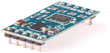
Figure 11.2 Schematic view of tilt sensor.
It is an actuator that senses sound waves through its intensity of receiving waves and converting it to electrical signals.
The sound sensor (Figure 11.3) is a component that includes a microphone and a processing circuit. This actuator is used to determine how loud a sound is. When a sound or noise is detected, the sensor generates an output signal in terms of voltage, which is transferred to a microcontroller, which subsequently does the required processing steps.

Figure 11.3 Schematic view of sound sensor.

Figure 11.4 Schematic view of GPS module.
The Global Positioning System (GPS) is a satellite-based system that measures and computes its position on Earth using satellites and ground stations [5]. For tracking or detecting a location, GPS receivers are commonly utilised in cell phones, fleet managing systems, and military applications. For accuracy, a GPS receiver must receive data from at least four satellites. The GPS receiver does not send any data to the satellites, and Figure 11.4 depicts the module.
This temperature sensor senses the temperature of the surroundings and measures in degree Celsius. The range of this sensor is -55°C to +150°C. There will be a change in accuracy of ±1/4°C.
It is a device used to display the results and outputs of various devices used in the system. 2*16 LCD means, 2 rows with 16 characters in each row [6]. +5V is the operating voltage of this LCD. It has 10 I/O pins contains of 8 data pins, register select and read/write pins.
A relay is a mechanical system which acts as a switch that is activated by an electrical current. The application of using relay is to transfer the current in one circuit which causes another circuit to open or close. Relays are employed when a circuit must be controlled by a separate signal or multiple circuits.
11.4 Results and Discussions
ThingView is an internet platform where we can store and retrieve data from the things or systems we are connected to. It is an open IoT platform and has MATLAB analytics.
In this ThingView platform, we can either access it in PC/laptop or mobile app for the purpose of storing and retrieving the data from the system. This platform will be connected to the cloud so that the real-time data can be updated accurately. Let us see how the app is used in this.
In the below Figure 11.5, we can observe the real-time readings of the system such as tilt sensor readings of X and Y axes, GPS co-ordinates latitude (LT) and longitude (LG), temperature reading and status of relay.
In order to show these outputs, we have written code with the help of Arduino IDE and backend code was given. So, with the instructions given in the program, the results are displayed in the application.
Working of the proposed method is shown in Figure 11.6 below.


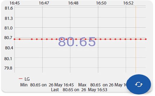
Figure 11.5 User interface of ThingView app and outputs.
Figure 11.6 Implementation and working of system.
From the Figure 11.6, we can observe the working process of the system. As the system works continuously all day it will store the data continuously. It shows all the required values such as tilting axis, GPS location, vibration data and temperature. Also, it will send the information whenever required to alert the user when any suspicious or poaching activities are detected with the help of Wi-Fi module ESP 8266 that is connected to a mobile application. So, the user is able to go through the details available in the application and can analyze the situation over there without being at the location physically.
From the below flow chart, Figure 11.7, we can clearly observe the working condition of the tilt sensor. The tilt sensor is connected to the Arduino board and continuously calculates the position of the tree with respect to reference plane. If there is any change observed in tilting axis of tree which is greater than the threshold limit, then the Arduino will immediately send the updated values along with GPS location to the user android application and alert the user that the tree has fallen. So, the user can immediately take necessary actions to prevent the theft.
From the below flow chart, Figure 11.8, we can observe the working and implementation of temperature sensor in this project. The temperature sensor is mainly used to focus on wildfire activities. Whenever fire occurs near the tree, automatically temperature increases at the surroundings. Now, after noticing the increased levels immediately Arduino will give a signal to relay module and update the status in the mobile application. Here relay plays an important role to control the forest fire. The relay will activate the water pump which will immediately release water in the location to tackle the fire.

Figure 11.7 Flow chart for tilt sensor.
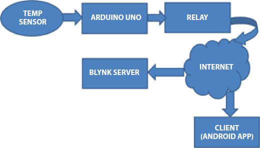
Figure 11.8 Flow chart of temperature sensor.
Figure 11.9 below shows the hardware output of the project.
This is the prototype that we will place in the forest area for anti-poaching purpose. The system consists of a buzzer which immediately alerts the surroundings when theft is happening (Figure 11.10). This prototype is connected to android application through Wi-Fi module and continuously transmits the data to the user. The software outputs are shown in Figure 11.5.
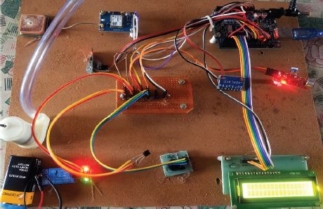
Figure 11.9 The proposed hardware prototype.

Figure 11.10 Forest prototype for display purpose.
11.5 Conclusion and Future Scope
This chapter has made a significant contribution to the field of wildlife safety systems, and it has been proposed using improvised methods. We saw the project as a journey on which we learned a lot of valuable lessons and gained new perspectives on the issue. We attempted to look at the problem from many perspectives, which resulted in the generation of some fresh ideas that could be investigated further in the future. The following are the project’s principal applications:
- Detects anti-poaching activities accurately.
- Sends accurate GPS locations.
- Can control Wildfire scenarios.
- It can also be used for household purposes.
When it comes to the paper future scope, while the design was successful and developments such as GPS technology were developed, there are still enhancements that might be done in future versions. The future scope of work will include the implementation of a camera vision technology to track live footage when poaching occurs as well as a multi-node network and the incorporation of a microphone motion detector sensor to improve systems’ ability to acquire data in the face of human or animal interference.
References
- 1. Joseph K. Paul, Tankala Yuvaraj, Karthikay Gundepudi, “Demonstrating Low-Cost Unmanned Aerial Vehicle for anti-Poaching”, in 2021 IEEE 17th India Council InternationalConference (INDICON). DOI: 10.1109/INDICON49873.2020.9342131
- 2. Prasanti, K., Seelam, K., Jayalakshmi, C., & Savalam, C. S., “Preventive system for forests property using wireless communication” (2019). Preventive system for forests property using wireless communication. 2019, 5th International Conference on Advanced Computing & Communication Systems (ICACCS). DOI: 10.1109/ICACCS.2019.8728514
- 3. P. G. Salunkhe, Poonam U. Chaudhari, “Design WSN Node for Protection of Forest Trees Against Poaching Based MSP430”, in 2018 International Conference On Advances in Communication and Computing Technology (ICACCT). DOI: 10.1109/ICACCT.2018.8529377
- 4. Mohan Sai S., Naresh K., RajKumar S.S., Mohan Sai Ganesh, Lok Sai, Abhinav, “An Infrared Image Detecting System Model to Monitor Human with Weapon for Controlling Smuggling of Sandalwood Trees”, in 2018 Second International Conference on Inventive Communication and Computational Technologies (ICICCT). DOI: 10.1109/ICICCT.2018.8473140
- 5. Pratiksha Bhuta, Ajay Khandare and Rakhshan Anjum Shaikh, “Protocol Implementation for Wireless Sensor Network for Anti-Poaching of Trees”, IEEE WISPNET 2017 conference. DOI: 10.1109/WiSPNET.2017.8299978
- 6. Anil Kulkarni, Ajay Khandare, Mandar Malve, “Wireless Sensor Network (WSN) for protection high-cost trees in remote jungles from fire and poaching”, in 2014 International Seminar on Sandalwood: Current Trends and Future Prospects.
- 7. M. Sathishkumar, S. Rajini, “Smart Surveillance System Using PIR Sensor Network and GSM”, 2015, International Journal of Advanced Research in Computer Engineering & Technology (IJARCET) Volume 4 Issue 1, pp. 45-76.
- 8. Prasad R. Khandar, K. Deivanai, “Preventive System for Forests” 2016, International Journal of Computer Science Trends and Technology (IJCST) – Volume 4 Issue 1, pp. 87-98.
- 9. Sarvesh Suhas Kapre, Saurabh Sahebrao Salunkhe, Rohan Manoj Thakkar, Akshay Prakash Pawar, and Omkar Ashok Malusare, “Advanced Security Guard with PIR Sensor for Commercial and Residential Use”, 2014, International Journal for Advance Research in Engineering and Technology (IJARET) Volume 2, pp. 765-775.
- 10. Gaurav Kumar, Kusum Gurja & Shyam Babu Singh, “American Sign Language Translating Glove using Flex Sensor”, 2016, Imperial Journal of Interdisciplinary Research (IJIR) Vol-2, Issue 6, pp. 456-461.
Note
- * Corresponding author: [email protected]