
3
Channel Modeling
The SNR at the detector input of a receiver is an important measure of telecommunication systems. If the SNR is ‘sufficiently’ high, that is the received signal power level is sufficiently higher than the received noise power level, the detector can decode the received symbols with minimum bit errors. Otherwise, reliable transmission of information from the transmitter to the receiver may not be possible.
The receiver noise will be studied in the next chapter. In this chapter, we will focus on the received signal power level that was calculated in Chapter 2 for free‐space propagation conditions in a wireless channel. In such channels, the received signal power level is determined by the transmit signal power level, transmit and receive antenna gains, range, and frequency (see (2.114)). However, in most applications, free‐space propagation may be hindered by the Earth’s curvature and/or the presence of obstacles, such as hills, buildings, and trees in the propagation path. Then, replicas of the transmitted signals may reach the receiver antenna via multi‐path propagation due to reflection, diffraction and scattering from the obstacles and refraction of electromagnetic waves in the troposhere. Electromagnetic waves are reflected from obstacles with dimensions comparable to the wavelength; reflected field strength is then a fraction of the incident field strength. Diffraction occurs when the propagation path is obstructed by objects with sharp edges; diffracted rays are received even in the regions with no LOS with the transmitter. The scattering is caused by rough obstacles that have irregularities much smaller than the wavelength. Consequently, electromagnetic wave propagation in a wireless channel largely depends on the frequency of operation and the characteristics of the propagation medium (cable, air, sea, ground, indoor/outdoor, and so on).
In this chapter, we will briefly mention about wave propagation in low‐frequency (LF: 30–300 kHz), medium‐frequency (MF: 300–3000 kHz) and high‐frequency (HF:3–30 MHz) bands. However, more emphasis will be given to wave propagation in very high frequency (VHF:30–300 MHz) and ultra high frequency (UHF:300 MHz–3 GHz) bands, allocated to FM radio, TV broadcasting, cellular radio, satellite communications (SATCOM), and so on. VHF and UHF bands provide a low‐noise spectral window for electromagnetic wave propagation (thus leading to lower receiver noise power). In addition, they allow electromagnetic waves to penetrate through walls with relatively low signal attenuation; this helps the provision of radio/TV broadcasting services and mobile radio signals to indoor users. Super‐high frequency (SHF) (3–30 GHz) and extremely high‐frequency (EHF) (30–300 GHz) bands (wavelengths λ < 10 cm) enable the use of physically small and yet high‐gain (narrow‐beamwidth) antennas. Such antennas can easily be installed on high grounds or towers to free the propagation path from obstacles so as to create free‐space propagation conditions. At frequencies higher than 10 GHz, atmospheric absorption and precipitation, such as snow and rain, cause additional signal attenuation and increase in the receiver noise. SHF and EHF bands are used for point‐to‐point LOS communications, satellite communications, radioastronomy, remote sensing and radar applications.
3.1 Wave Propagation in Low‐ and Medium‐Frequency Bands (Surface Waves)
In LF and MF bands, the waves are guided by the Earth’s surface. Hence the so‐called surface waves are influenced by physical and electrical characteristics of the Earth’s surface. Bearing in mind that the wavelength in LF and MF bands changes between 10 m–1 km and 1000 m–100 m respectively, transmit and receive antennas are electrically short monopoles and are erected over the surface of the Earth. Since the ground is highly conductive at these frequencies, electromagnetic waves radiated by horizontal antennas are attenuated much more rapidly compared to those radiated by vertical antennas. Radiated electric fields with horizontal polarization attenuate rapidly with distance by inducing currents on the Earth’s surface, instead of carrying the transmitted information to long distances. Therefore, the use of vertical antennas above the Earth’s surface lead to surface waves with vertical polarization. The received electric field in the far‐field is formed by the complex interaction of direct (LOS) and Earth‐reflected signals. In LF and MF bands, electromagnetic waves follow the contour of the Earth. Transmit monopole antennas with directivities typically less than 2 dBi and transmit power levels exceeding 10 kW are commonly used.
Received electric field intensity of the surface wave with vertical polarization may be written, in terms of the LOS electric field strength, ELOS, as [1]
assuming that the Earth’s surface is flat, that is, the range is less than ![]() , and that the relative dielectric constant εr of the Earth is larger than 10. As shown by (3.1), the presence of the Earth modifies the received LOS electric field strength by a factor of 2As. Since As ≤ 1, the received field strength is less than 2ELOS which corresponds to the case where direct and Earth‐reflected fields arrive in phase to the receiver. For flat‐Earth assumption, the surface wave attenuation factor As is given by [1]
, and that the relative dielectric constant εr of the Earth is larger than 10. As shown by (3.1), the presence of the Earth modifies the received LOS electric field strength by a factor of 2As. Since As ≤ 1, the received field strength is less than 2ELOS which corresponds to the case where direct and Earth‐reflected fields arrive in phase to the receiver. For flat‐Earth assumption, the surface wave attenuation factor As is given by [1]

The Earth surface is electrically characterized by its conductivity σ (S/m) and relative dielectric constant εr. Some typical values are presented in Table 3.1.
Table 3.1 Typical Values of Conductivity and Relative Dielectric Constant of the Earth’s Surface.
| Earth’s surface | Conductivity σ (S/m) | Relative dielectric constant εr |
| Poor ground | 0.001 | 4–7 |
| Average ground | 0.005 | 15 |
| Good ground | 0.02 | 25–30 |
| Sea water | 5 | 81 |
| Fresh water | 0.01 | 81 |
Since the sea water behaves like a perfect conductor, LF waves propagate over sea surface much larger distances (with relatively small attenuation) compared to free space propagation. Therefore, spherical Earth propagation conditions are often needed. Attenuation of surface waves over spherical Earth is more rapid compared to the flat‐Earth.
Surface waves are guided by the Earth surface; they are attenuated with increasing height from the surface of the Earth and cannot penetrate through the surface of the Earth. The penetration depth dp of the electric field into the ground/sea is determined by its skin depth:

where z denotes the distance from the Earth’s surface in the direction of the center of the Earth. The penetration depth in the sea water is found to be δs = 0.25 m at 1 MHz.
In LF, surface waves are used for long distance communications and navigation, while MF band (frequencies lower than 2 MHz) is mostly exploited for AM broadcasting due to larger available bandwidth. The range of surface waves can typically be several hundred kilometers at broadcast frequencies, dropping to 20 km or so at 100 MHz, but much higher over the sea. At broadcast frequencies, the noise level in urban areas is so high that field strength of 1–10 mV/m at the receiving antenna is required for acceptable reception. In rural areas signal levels of an order of magnitude less are satisfactory, due to lower external noise coupled into the receive antenna. During the night‐time, slow fading is observed with fade durations of tens of seconds due to interference between surface and ionospheric waves (3–30 MHz) at the upper part of the MF band.
3.2 Wave Propagation in the HF Band (Sky Waves)
The HF band covers the frequencies between 3–30 MHz; the corresponding wavelength interval is 10–1 m. The wave propagation in the HF band may be considered as guided by the parallel‐plate waveguide formed by the Earth surface and the layers of the ionosphere, between 40–400 km heights over the Earth’s surface. The so‐called sky waves are returned down to Earth from the ionosphere due to the refraction phenomenon. Ability of ionosphere to refract (return) electromagnetic waves toward the Earth depends on frequency, angle of transmission and the ion/electron density, which is a function of time of the day. This ability is improved with the increased ionization density which is higher during the day than at night, in summer than in winter and during periods with higher solar activity than in periods with quiet sun. As the frequency of operation increases in the HF band, we observe an increase in the ionospheric height at which ionospheric waves are returned. Electromagnetic waves at frequencies higher than the HF band go through the ionosphere since ionization density is not sufficiently high so as to refract (return) them back to the Earth. At higher end of the MF and lower end of the HF bands, interference between ionospheric and surface waves may be observed.
Sky waves can travel a number of hops, back and forth between ionosphere and Earth’s surface. The refracting/reflecting process between the ionosphere and the ground is called skipping. Skip distance is in the order of several hundred km. This allows long distance communications and broadcasting over thousands of km. HF signals undergo strong fading due to time‐varying and nonhomogeneous character of the ionization density, which varies with geographical location, time of day, and season.
The ionosphere is usually considered to be stratified in terms of the height over the Earth’s surface into D‐layer (40–90 km), E‐layer (90–140 km) and F‐layer (140–400 km). D‐layer has the ability to refract signals of lower frequencies due to lower electron concentration. High frequencies pass through it with partial attenuation. Being affected by the solar activity, this layer disappears after sunset, due to rapid rate of recombination which is almost complete by midnight. Consequently, signals normally refracted by D‐layer are refracted at night by higher layers, resulting in longer skip distances. E‐layer refracts signals of frequencies less than 30 MHz but higher compared to frequencies that can be refracted by the D‐layer. F‐layer separates into F1 and F2 layers during daylight hours. Ionization level is very high and varies widely during the day and recombination occurs slowly after sunset. A fairly constant ionization layer is present at all times but F2 is most affected by solar activity. E‐ and F‐layers are permanent but their heights differ.
HF band is mainly used for short‐wave radio, amateur radio and military communications. Since the antenna noise is very high and multipath propagation is inherent, sky waves undergo strong fading; the SNR at the receiver is generally low and undergo fast random fluctuations. Consequently, the available 27 MHz bandwidth in the HF band is troublesome for high data rate and high quality communications.
The following ionospheric effects are usually accounted for in terms of the total electron content (TEC) along the propagation path: [2]
- The so‐called Faraday rotation accounts for the progressive rotation of the plane of polarization of a linearly polarized wave, propagating through the ionosphere. The amount of rotation is a function of the TEC. In many applications, TEC is estimated and induced polarization rotation is corrected.
- Dispersion of ionospheric signals results in time delay differences across the bandwidth of the transmitted signal;
- Inhomogeneities in the TEC lead to amplitude fluctuations called as scintillations. The resulting phase and amplitude scintillations cause focusing or defocusing of radio waves. Scintillations decrease with increasing frequency and depend upon path geometry, location, season, solar activity and local time.
3.3 Wave Propagation in VHF and UHF Bands
VHF and UHF bands cover 30–300 MHz and 300–3000 MHz bands, respectively. The corresponding wavelengths are 10–1 m for VHF and 1–0.1 m for UHF. Therefore, the required physical size of an antenna for a given antenna electrical size is relatively small. Consequently, antennas can be mounted to masts or on the roofs of high buildings to enlarge the coverage area, which is restricted mainly to LOS and influenced by the presence of Earth and other obstacles. Coupling between transmit and receive antennas is hence accomplished via direct, Earth‐reflected and scattered rays. Consequently, the receiver proceses multiple copies of the same signal with varying amplitude, phase and delay for signal detection. Constructive and destructive interferences between direct (LOS) and Earth‐reflected rays result in oscillations around the received LOS signal power level which attenuates with distance as r−2. As the range exceeds a crital distance, the received signal power level fades away in proportion to r−4.
VHF and UHF bands are allocated mainly to FM and TV broadcasting, radio‐link, mobile radio, SATCOM, and so on. This allocation is justified by the fact that the waves in these bands can penetrate walls with relatively small loss. Since the antenna noise decreases with increasing frequencies, the systems operating in VHF and UHF bands have the potential of being less noisy. On the other hand, atmospheric absorption and rain attenuation are negligibly small in these bands. The effects of troposheric refraction, that is, bending of radio waves as they propagate through the troposhere, are accounted for by assuming an equivalent Earth radius of 8500 km which is 4/3 times the actual Earth radius. The problems related to digital signaling such as frequency dependence of attenuation and delay as well as intersymbol interference (ISI), due to bandwidth limitation by the channel and/or multipath propagation, will be studied in detail in the following chapters.
3.3.1 Free‐Space Propagation
The wave propagation is said to take place in free space, if there is no obstacle, including the Earth, and if atmospheric absorption and precipitation do not have any effect on wave propagation between transmit and receive antennas. The power received by the receive antenna under free space propagation conditions is given by (2.117).
Free‐space communications, which comprises a single propagation path, may be modelled by an AWGN channel. In this channel, the low‐pass equivalent received signal rℓ(t) may be written in terms of the low‐pass equivalent transmitted signal sℓ(t) as

where α (see (2.114)) and ϕ denote respectively the attenuation constant and the phase shift due to the channel and are assumed to be deterministic. The delay τ is defined by the ratio of the range r to the velocity of light. One may rewrite (3.5) in the classical form of an AWGN channel by dividing both sides of it with ![]() :
:

Note that rescaling the received signal level by ![]() does not affect SNR since the SNR given by (3.5) and (3.6) are the same.
does not affect SNR since the SNR given by (3.5) and (3.6) are the same.
3.3.2 Line‐Of‐Sight (LOS) Propagation
In practice, the propagation environment between transmit and receive antennas can not be modelled as free space due to the presence of buidings, trees, hills and other obstacles causing scattering of electromagnetic waves. Even if transmit and receive antennas are in line‐of‐sight (LOS) of each other, in addition to the direct ray, some rays arrive to the receive antenna terminal via scattering from these obstacles.
The low‐pass equivalent signal rℓ(t) received in a multipath channel may be characterized in terms of the low-pass equivalent transmit signal sℓ(t) and the impulse response h(t) by

where L replicas of the transmitted low‐pass equivalent signal sℓ(t) with different amplitudes, phases and delays reach the receiver. If the amplitudes αi of some multi‐path components are small compared to the dominant one, then they may be ignored. The channel induces ISI if ![]() is larger than a significant fraction of the signal duration. Then signal components, which are scattered from obstacles far from the LOS, arrive late and interfere with subsequently transmitted signals. This causes ISI and leads to errors in signal detection. However, if τmax is small fraction of the signal duration, then the signaling becomes ISI free.
is larger than a significant fraction of the signal duration. Then signal components, which are scattered from obstacles far from the LOS, arrive late and interfere with subsequently transmitted signals. This causes ISI and leads to errors in signal detection. However, if τmax is small fraction of the signal duration, then the signaling becomes ISI free.
Here, the fundamental problem is to decide about the number of scatterers which contribute significantly to the received signal. This decision is closely related to the electrical size of an obstacle and its distance to the LOS path. Noting that larger obstacle sizes are needed for significantly high scattered signal power levels at lower frequencies, the number L of scatterers is expected to be larger at higher frequencies in a propagation path. Then, the received signal given by (3.7) is better described by integration rather than summation. For small L, one may trace the rays between transmitter and receiver via scatterers which induce sufficiently large signal power levels at the receiver. This may be a convenient approach in VHF and in the lower part of the UHF band but, at higher frequencies, ray tracing becomes practically impossible since L is potentially very large. The multipath channel is then characterized statistically. This case will be studied in detail in the forthcoming chapters.
3.3.3 Fresnel Zones
A LOS path is said to be clear when there are no scatterers in the close vicinity of the direct path between the transmitter and the receiver. As shown in Figure 3.1, the clearance of the LOS path is affected by heights of transmit and receive antennas, terrain profile (hills, buildings), terrain cover (vegetation), Earth’s curvature, troposheric refraction, and so on. The concept of Fresnel zone provides a practical measure of the clearance of the LOS path.

Figure 3.1 Propagation Path with Reflection, Diffraction and Scattering.
An ellipse is defined as the locus of points on a plane so that sum of the distances to the foci (two fixed focal points) is constant. If an ellipse is rotated around the axis which connects the two focal points, then the three‐dimensional curve thus formed becomes an ellipsoid. If transmit and receive antennas are located at the focal points, then the path lengths of signals reflected, scattered or diffracted from obstacles located on the surface of the same ellipsoid are the same (see Figure 3.2). This also implies that these signals also suffer the same propagation delay and the same phase shift at the receiver input. The line connecting the two focal points represents the direct path between transmit and receive antennas. Thus, the excess path length, that is, the path length difference between the direct ray and the rays scattered from the surface of an ellipsoid, is also a constant. Thus, phase and delay differences are also constants. It should also be evident that path length/phase/delay difference increases with increasing sizes of concentric ellipsoids around the direct path.

Figure 3.2 Signals Arrive at the Receiver Antenna at the Same Time if They are Scattered by Obstacles That are Located on the Surface of the Same Ellipsoid.
Fresnel zone concept is used to specify these differences. For example, nth Fresnel zone is defined by an ellipsoid where the excess path‐length is less than nλ/2; this implies a phase difference of nπ and a delay difference of nλ/(2c) where c denotes the velocity of light. The first Fresnel zone is defined as an ellipsoid where the excess path length is less than or equal to λ/2. Hence, the phase difference between rays scattered from obstacles located in the first Fresnel zone is always less than or equal to 180 degrees. Objects within a series of concentric ellipsoids around the LOS between transceivers have therefore constructive/destructive interference effects on the received signal. In practice, the communications is assumed to take place in free space conditions if the first Fresnel zone is free of scatterers. The signals scattered from regions defined by higher order Fresnel ellipsoids may be neglected since these signals will be much more attenuated compared to the direct signal.
Now consider that transmit and receive antennas of a communication system are located at the foci of an elllipsoid as shown in Figure 3.3. The reflection point on the ground, which remains on the surface of an ellipsoid with distance h to the LOS at that point, is assumed be d1 (m) away from the transmitter. The excess path length between reflected and direct rays is found from Figure 3.3:

where we used the binomial approximation ![]() . This approximation is valid when the height h is much less than d1 and d2, which is reasonable in practical applications. The loci of points at which the excess path length is equal to nλ/2 is given by hn, which denotes the height of nth Fresnel zone at distance d1 from the transmitter:
. This approximation is valid when the height h is much less than d1 and d2, which is reasonable in practical applications. The loci of points at which the excess path length is equal to nλ/2 is given by hn, which denotes the height of nth Fresnel zone at distance d1 from the transmitter:


Figure 3.3 Fresnel Zone Height.
The corresponding phase difference is given by

The phase difference between the direct ray and the rays scattered by scatterers on the surface of the nth Fresnel ellipsoid is given by
Contributions to the received signal from successive Fresnel zones tend to be in phase opposition and interfere with each other destructively. The contributions to the received signal level from scatterers in the nth Fresnel zone would be less than those in the (n‐1)th Fresnel zone.
Received signal level is considered to be significant only from scatterers which are located in the first Fresnel zone. Antenna heights in point‐to‐point links are usually selected so that the first Fresnel zone is clear. We know from geometrical considerations that the maximum value of hn occurs at the mid‐point of the direct path d1 = d2. In terrestrial links, one should check whether the point of reflection remains in the first Fresnel zone. However, in Earth‐space links, the scatterers in close vicinity of the ground station antenna may remain in the first Fresnel zone. In VHF and UHF bands, the Earth is usually located in the first Fresnel zone and free space propagation conditions do not exist. Therefore, signal propagation takes place via direct, Earth‐reflected and scattered rays due to obstacles located in the first Fresnel zone. For example, consider a communication system with d1 = d2 = 10 km. The height of the first Fresnel zone is found from (3.9) as ![]() , which is equal to 122.5 m for a FM radio channel at 100 MHz and 40.8 m for a GSM system operating at 900 MHz. In both cases, the Earth surface will be located in the first Fresnel zone in most operational scenarios. On the other hand, the height of a Fresnel ellipsoid is proportional to
, which is equal to 122.5 m for a FM radio channel at 100 MHz and 40.8 m for a GSM system operating at 900 MHz. In both cases, the Earth surface will be located in the first Fresnel zone in most operational scenarios. On the other hand, the height of a Fresnel ellipsoid is proportional to ![]() . This means that a Fresnel zone becomes more concentrated along the direct path with increasing frequencies. Consequently, it is easier to clear the first Fresnel zone at higher frequency bands, where antennas are physically smaller and can easily be mounted on masts and/or roof tops.
. This means that a Fresnel zone becomes more concentrated along the direct path with increasing frequencies. Consequently, it is easier to clear the first Fresnel zone at higher frequency bands, where antennas are physically smaller and can easily be mounted on masts and/or roof tops.
We will hereafter assume that free‐space propagation conditions apply when the first Fresnel zone is clear. If not, in addition to the direct (LOS) signal, the received signal will be determined by taking into account of the contributions of all obstacles located in the first Fresnel zone. These can reflect, diffract or scatter the incident signals. The reflection is often from the Earth’s surface which may be smooth to cause specular reflection, or rough so as to cause diffuse reflection or scattering of the incident rays. Besides, hills with sharp edges, roof tops of buildings and other metallic objects may diffract electromagnetic waves.
Below we will first consider the diffraction of electromagnetic waves from obstacles located in the first Fresnel zone and then study reflection from Earth’s surface with flat and spherical Earth assıumptions as well as for the cases of smooth and rough surfaces.
3.3.4 Knife‐Edge Diffraction
Here we will study the diffraction of electromagnetic waves from sharp edges of conducting obstacles located in the first Fresnel zone. As shown in Figure 3.4, a receiver may be located either in the illuminated or the shadow region, which are separated from each other by the shadow boundary. Illuminated (shadow) region is defined as the region where the direct (LOS) ray is (not) available. When a receiver located in the illuminated region, it can receive both the direct (LOS) signal and the signal diffracted by the edge. However, a receiver located in the shadow region can receive only the diffracted ray, since the direct ray is blocked.

Figure 3.4 Knife‐Edge Diffraction.
Using (3.10) the phase difference between direct and diffracted rays may be related to the so‐called Fresnel‐Kirchhoff diffraction parameter ν as

As shown in Figure 3.5, h denotes the height of the diffracting screen above (below) the LOS, if the LOS is (not) blocked by the screen. If the diffracting edge just touches the LOS between transmitter and receiver, that is, in the shadow boundary, then h = v = 0. Note that, ![]() when LOS is blocked by the edge and
when LOS is blocked by the edge and ![]() in the presence of LOS between transmitter and receiver. Hence, being directly proportional to h, the Fresnel‐Kirchhoff diffraction parameter v provides a measure of the closeness of the diffracted ray to the LOS.
in the presence of LOS between transmitter and receiver. Hence, being directly proportional to h, the Fresnel‐Kirchhoff diffraction parameter v provides a measure of the closeness of the diffracted ray to the LOS.

Figure 3.5 Knife‐Edge Diffraction Scenarios With and Without LOS.
According to Huygens‐Fresnel principle, the electric field intensity Ed at the observation point may be written in terms of the electric field intensity Ei incident at the point of diffraction as [1]

The Fresnel integrals C(v) and S(v) vanish and the received electric field intensity becomes equal to Ed = Ei/2 at v = 0, that is, when the receiver located on the shadow boundary. Physically, this means that half of the incident electric field intensity (Ei/2) goes directly to the receiver, whereas the other half is reflected back by the surface of the screen. For large positive values of v (in the shadow region), the Fresnel integrals C(v) and S(v) approach ½ and the received electric field intensity Ed vanishes (see Figure D.6). On the other hand, as ![]() (in the illuminated region), one may use C(−v) = −C(v) and S(−v) = −S(v) to show that the received electric field intensity Ed oscillates around and eventually approaches the direct ray Ei.
(in the illuminated region), one may use C(−v) = −C(v) and S(−v) = −S(v) to show that the received electric field intensity Ed oscillates around and eventually approaches the direct ray Ei.
The so‐called diffraction loss represents the signal power loss between diffraction and observation points. Using (3.13), the diffraction loss may be expressed as follows:

which is defined to be positive when Ed is smaller than Ei, that is, in the shadow region (see Example D.1). For v > −0.7, the diffraction loss L(v) may be approximated as [3]

The knife‐edge diffraction formulation presented above is valid for diffraction from sharp edges. However, the edges need not to be sharp for diffracting the incident rays. For a given path clearence, the diffraction loss will vary from a minimum value for a single knife‐edge diffraction to a maximum for smooth spherical Earth, which may be more applicable in rural areas. Empirical diffraction loss for average terrain is approximated by [4]
which is valid for losses greater than about 15 dB and h is defined as the height difference between most significant path blockage and path trajectory. The diffraction loss for smooth spherical Earth at 6.5 GHz and k = 4/3 Earth is approximated by [4]
which is also valid for losses greater than about 5 dB.
Figure 3.6 shows the variation of the theoretical knife‐edge diffraction loss by (3.14) and its approximation by (3.15). Note that the diffraction loss increases with increasing values of v. In the shadow region (for v > 0), only the diffracted rays reach the receiver. Consequently, the diffraction loss increases with increasing values of v and h, that is, as shadowing becomes more intense. However, for v < 0 (in the illuminated region), Ed given by (3.13), which represents the phasor sum of direct and diffracted rays, oscillates around Ei (represented by 0 dB level in Figure 3.6). Consequently, the negative values of the diffraction loss imply constructive interference between direct and diffracted rays; hence, signal levels is higher than the direct signal level Ei. Figure 3.6 also shows empirical diffraction loss and smooth Earth diffraction loss in comparison with the theoretical knife‐edge diffraction loss. Diffraction loss was observed to increase as the diffracting edge becomes smoother. For v = 2, the diffraction losses for theoretical knife edge, empirical and smooth Earth are found using (3.15)–(3.17) to be 19.1 dB, 38.4 dB and 53.8 dB, respectively.

Figure 3.6 Diffraction Loss.
In order to determine the electric field intensity at the observation point, we first express the rms value of the incident electric field intensity at the point of diffraction, as given by (2.119),

where Pt denotes the transmit power, Gt is the transmit antenna gain in the direction of the diffracting edge and r1 denotes the distance between the transmitter and the point of diffraction. From (3.14) and (3.18), the rms value of the diffracted electric field intensity is found to be

The received diffracted signal power at the observation point is found using (2.120) and (3.19):

where ![]() denotes the free space loss between the transmitter and the point of diffraction.
denotes the free space loss between the transmitter and the point of diffraction.
When the separation between transmitter and receiver is much longer compared to the height of the diffracting screen, one might assume ![]() in Figure 3.5. Then, the ratio of the received diffracted signal power and free‐space signal powers at the observation point may be written as
in Figure 3.5. Then, the ratio of the received diffracted signal power and free‐space signal powers at the observation point may be written as

This ratio is mostly less than unity, implying that received signal power due to diffraction is lower than that for free‐space propagation.

Figure 3.7 Geometry of Double Knife‐Edge Diffraction.

Figure 3.8 A Knife‐Edge Diffracting Obstacle in the First Fresnel Zone.
3.3.5 Propagation Over the Earth Surface
In VHF and UHF bands, free‐space propagation conditions apply only under restricted cases. Effects of obstructions on the ground or the turbulent sea should be considered, since the first Fresnel zone usually comprises the Earth’s surface. Therefore, VHF and UHF wave propagation in urban, suburban, and rural areas and over sea show significant differences.
Two issues are of primary interest in propagation over the Earth surface in VHF and UHF bands. Firstly, the Earth surface may be assumed to be flat when the range r satisfies
For example, at f = 1 MHz the Earth may be assumed to be flat for ranges not exceeding 80 km, but the range reduces to 8.3 km at f = 900 MHz. Therefore, transmit and receive antennas should be raised more to compensate for the curvature of the Earth, which limits the LOS distance and hence the communication range. The second issue stems from the roughness of the Earth surface, which is measured in terms of the standard deviation of surface irregularities compared to the local mean level at the point of reflection/scattering. Depending on surface roughness, the electrical parameters of the ground, frequency of operation and the angle of incidence ψ (see Figure 3.9), electromagnetic waves undergo specular/diffuse reflection or scattering. Consequently, the roughness of the Earth surface strongly affects the intensity of the surface‐reflected signals at the receiver.
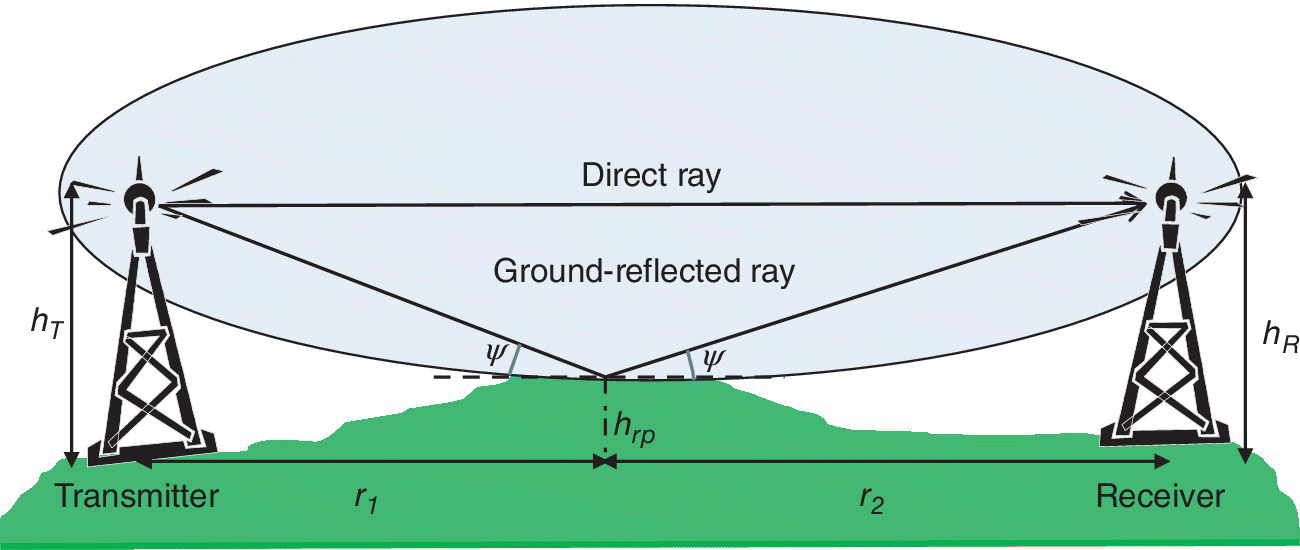
Figure 3.9 Signal Transmission Via Direct and Ground‐Reflected Rays.
We will first determine the reflected electric field intensity at the receiver, as shown in Figure 3.9, based on the assumption that the Earth surface is flat and smooth at the reflection point. It is also assumed that the height of the reflection point hrp coincides with the line connecting transmit and receive antennas. Otherwise, transmit and receive antenna heights should be adjusted accordingly, that is, as hT‐hrp and hR‐hrp (see Figure 3.9). [4] Based on these assumptions, the point of reflection is determined by the law that the angle of incidence is equal to the angle of reflection:
Here r = r1 + r2 denotes the distance between transmitter and receiver where r1 (r2) is the distance between the point of reflection and the transmitter (receiver). The point of reflection moves away from the transmitter with increasing values of hT. For the special case when hT = hR, one gets r1 = r2 = r/2. Similarly, if hT = 10 m, hR = 20 m and r = 30 km, then r1 = 10 km and r2 = 20 km.
Reflection coefficient, which is defined as the ratio of the reflected field intensity to the incident field intensity at the point of reflection, depends on the carrier frequency, dielectric constant and conductivity of the Earth, the angle of incidence and the polarization of the incident wave. We assume that the Earth is flat and smooth at the point of reflection. Furthermore, the point of reflection is assumed to be in the far‐field of the transmitter and receiver so that the fields have planar wave‐fronts. For horizontal and vertical polarization, the reflection coefficient over a lossy dielectric flat Earth surface is given by: [4][6]

where ψ denotes the angle of incidence with respect to the horizon. Similarly, εr and σ denote respectively the relative dielectric constant and the conductivity of the Earth’s surface at the point of reflection. Figures 3.10 and 3.11 show the variation of the complex reflection coefficients over average Earth (σ = 5 × 10⁻³ and εr = 15 from Table 3.1) for horizontal and vertical polarizations, respectively. Horizontal polarization refers to the case where the incident electric field is polarized parallel to the surface of the Earth, that is, perpendicular to the surface of the paper in Figure 3.9. In vertical polarization, the incident electric field is polarized parallel to the surface of the paper and perpendicular to the direction of propagation. The parameter x denotes the ratio of the conduction current to the displacement current at the point of reflection at a given frequency. The magnitudes of the reflection coefficients for both horizontal and vertical polarization increase with increasing values of x, that is, decreasing values of the frequency. This implies that the Earth’s surface behaves as more conductive and yields higher reflection coefficients at lower frequencies. In case of vertical polarization, the reflection coefficient has a minimum at the so‐called pseudo‐Brewster angle, which is a function of x.

Figure 3.10 Magnitude and Phase of the Reflection Coefficient for Horizontal Polarisation Over Average Ground (σ = 5 × 10⁻³ and εr = 15).

Figure 3.11 Magnitude and Phase of the Reflection Coefficient for Vertical Polarisation Over Average Ground (σ = 5 × 10⁻³ and εr = 15).
In many cases of interest, the height of transmit and receive antennas are much smaller compared to r1 and r2. The angle of incidence then becomes very small so that ![]() ; then, the reflection coefficients for horizontal and vertical polarizations tend to be −1:
; then, the reflection coefficients for horizontal and vertical polarizations tend to be −1:

Typical values for the conductivity and the relative dielectric constant of the Earth’s surface are presented in Table 3.1.
3.3.5.1 Propagation Over Flat Earth Surface
As shown in Figure 3.12 transmit and receive antennas are located above the Earth surface which is assumed to be flat and smooth. Thus direct‐ and ground‐reflected rays contribute to the received electric field intensity:

where d1 and d2 denote respectively the path lengths of direct and reflected rays. One may rewrite (3.36)

where the received electric field intensity is expressed as the product of the direct ray and the so‐called array factor fa, which represents the contribution of the Earth‐reflected ray to the received signal strength. The excess path length d2‐d1 for large r = r1 + r2 and r >> hT, hR, is found from Figure 3.12:


Figure 3.12 Direct and Reflected Rays Between Transmitter and Receiver.
For sufficiently large separations r between transmitter and receiver, we can assume ![]() (see 3.35). Then the array factor reduces to
(see 3.35). Then the array factor reduces to

It is evident from (3.37) and (3.39) that the Earth‐reflected ray interferes with the direct ray; the received electric field intensity is equal to twice that of the direct ray when the phase difference between them is an even multiple of π and vanishes for odd multiples of π. Hence, the maxima of the array factor given by (3.39) occur at
Similarly, the minima occur at
Figure 3.13 shows the variation of the array factor given by (3.39) with the electrical height of the receive antenna hR/λ for r/hT = 10. Free space signal propagation condition is represented by ![]() . The optimum receiver height corresponds to the minimum value of hR that maximizes the array factor, that is, n = 1 in (3.40). The optimal receiver height is then given by
. The optimum receiver height corresponds to the minimum value of hR that maximizes the array factor, that is, n = 1 in (3.40). The optimal receiver height is then given by

Figure 3.13 Variation of the Array Factor with hR/λ for r/hT = 10.
For λ = 0.1 m (f = 3 GHz), hT = 10 m and r = 1 km, the optimum receiver height is found to be hR,opt = 2.5 m.
In the presence of only direct and Earth‐reflected rays, the received signal power Pr may be written as the product of the LOS signal power and ![]() :
:

Figure 3.14 shows the variation of (3.43) with distance r for hT = 10 m, hR = 1.6 m, λ = 1/3 m (f = 900 MHz) and ![]() . For small values of r, one observes strong oscillations in the received signal power due to constructive/destructive interferences between direct and reflected rays. Consequently, the received signal power might be 6 dB higher than the free‐space value at points determined by (3.40) and vanish at points determined by (3.41). For large values of r, the reflection coefficient approaches −1 since the elevation angle approaches zero and the frequency of oscillations decreases.
. For small values of r, one observes strong oscillations in the received signal power due to constructive/destructive interferences between direct and reflected rays. Consequently, the received signal power might be 6 dB higher than the free‐space value at points determined by (3.40) and vanish at points determined by (3.41). For large values of r, the reflection coefficient approaches −1 since the elevation angle approaches zero and the frequency of oscillations decreases.

Figure 3.14 Variation of the Received Signal Power with Range for hT = 10 m, hR = 1.6 m, λ = 1/3 m (f = 900 MHz) and  .
.
The furthest signal maximum from the transmitter corresponds to the largest value of r that maximizes the array factor, that is, n = 1 in (3.40):
Note from (3.38) that rmax represents the largest distance at which the path difference d2‐d1 between direct and reflected rays is equal to λ/2. This implies that the point determined by rmax is located on the surface of the first Fresnel ellipsoid; ignoring the reflection coefficient, which is equal to −1 two paths interfere destructively with each other since the phase difference between them is equal to π radians. At distances shorter than rmax, the signal power decreases in proportion to 1/r2, since the array factor varies over the range −2 and 2. However, at distances r > rmax, the argument of sine in (3.39) becomes much smaller than π/2 and one can use the approximation sin(x) ≅ x in (3.43) to get

where Lpe denotes the so‐called plane‐Earth path‐loss:

Beyond rmax the signal power decreases monotonically as 1/r4.

Figure 3.15 Path Loss as a Function of the Horizontal Distance Between a Ground‐Based Transmitter and an Air‐Borne Receiver. Heights of transmit and receive antennas are given by hT = 10 m and hR = 1000 m, respectively.
3.3.5.2 Propagation Over Spherical Earth Surface
When the distance between transmitter and receiver does not satisfy the condition given by (3.32), the Earth’s surface can not be assumed flat. We then need to account for the effect of the Earth’s curvature on the electric field reflected from the Earth’s surface. In this case, the Earth is assumed to be spherical with an effective radius of ![]() , where a = 6371 km denotes the physical Earth radius. As it will be explained in the following sections, the factor 4/3 accounts for the refraction (bending) of electromagnetic waves in the troposhere. Therefore, the electromagnetic waves are implicitely assumed to propagate along straight lines over the surface of the Earth with an equivalent radius of 8500 km.
, where a = 6371 km denotes the physical Earth radius. As it will be explained in the following sections, the factor 4/3 accounts for the refraction (bending) of electromagnetic waves in the troposhere. Therefore, the electromagnetic waves are implicitely assumed to propagate along straight lines over the surface of the Earth with an equivalent radius of 8500 km.
Unlike on the flat Earth‐surface, one may observe from Figure 3.16a that the ‘effective’ antenna height observed on spherical Earth‐surface is lower than its physical height. From Figure 3.16b, one may find the effective antenna heights as


Figure 3.16 Effective Antenna Heights for Reflection Over Spherical Earth.
For field calculations over spherical Earth, {hT, hR} appearing in (3.33)–(3.46) for propagation over flat‐Earth should be replaced by ![]() .
.
On the other hand, a bundle of parallel rays incident on the surface of flat Earth are reflected parallel to each other. However, they diverge after reflection from the surface of spherical Earth, thus leading to a decrease in the reflection coefficient (see Figure 3.17). The rays will evidently diverge more for decreasing values of the angle of incidence, which is directly proportional to the antenna heights and inversely proportional to the range. The divergence factor D, which accounts for the divergence of electromagnetic waves as they are reflected over spherical Earth‐surface, is given by: [4]


Figure 3.17 Reflection Over Flat and Spherical Earth Surface.
Note that D = 1 for flat surface but D < 1 for the spherical Earth. Figure 3.18 shows the variation of the divergence factor as a function of range for hR = 2 m and various values of hT. Note that small values of the divergence factor at large distances from the transmitter may help reducing the fades due to interference between direct and reflected rays.

Figure 3.18 Divergence Factor Versus Range in km for hR = 2 m and Various Values of hT.
3.3.5.3 Effect of Surface Roughness on Reflection
So far we discussed the reflection of electromagnetic waves from smooth surfaces only; then, the reflection is in the specular direction, which is determined by the law that the angle of incidence equals the angle of reflection. For specular reflection, smooth Earth reflection coefficients, given by (3.34), are used to determine the reflected field strength (see Figure 3.19a). As shown in Figure 3.19b, incident rays reflected by a rough surface in off‐specular directions have a nonnegligible part of the total reflected signal energy. In this so‐called diffuse reflection process, the energy of the reflected field in the specular direction is reduced at the expense of the energy reflected in other directions. Thus, the reflection coefficient becomes smaller and the direction of reflection broadens. In the extreme case of reflection from rough surfaces as shown in Figure 3.19c, the process is described as scattering rather than reflection. In this process, the smooth Earth reflection coefficient can not be used since incident rays are scattered randomly in all directions and only a small fraction of the scattered energy is received by the receiver. This implies that the scattered signals have negligible contribution to the received electric field intensity.

Figure 3.19 Effect of Surface Roughness on the Reflection.
The extent of scattering depends on the angle of incidence and the surface roughness in comparison to the wavelength. The apparent roughness of a surface is reduced as the angle of incidence becomes closer to grazing incidence, and/or the wavelength becomes larger. Here we will define the surface roughness to make a quantitative distinction between smooth and rough surfaces. Consider the reflection of two rays from a rough surface, as shown in Figure 3.20, one from the local mean level and the other from an obstacle of height σ, which represents the standard deviation of the surface irregularities with respect to the local mean height. The phase difference between the two rays may be written as
where Δℓ shows the excess path length, that is, the path length difference between rays 1 and 2. The reflection is said to be specular if ![]() (reflecting surface is smooth), that is, when Δϕ is sufficiently small. On the other hand, a rough surface corresponds to a phase difference of
(reflecting surface is smooth), that is, when Δϕ is sufficiently small. On the other hand, a rough surface corresponds to a phase difference of ![]() where direct and reflected rays cancel each other. The dividing line between rough and smooth surfaces is taken as
where direct and reflected rays cancel each other. The dividing line between rough and smooth surfaces is taken as ![]() . Hence, a reflecting surface is said to be smooth if
. Hence, a reflecting surface is said to be smooth if
where one may use (3.33) to express ψ in terms of hT, hR, and r as


Figure 3.20 Definition of the Surface Roughness.
The Rayleigh roughness criterion specifies the maximum allowable surface deviation (relative to a perfectly flat surface) in order for a surface to be considered smooth. The variation of the standard deviation of the surface irregularities is plotted in Figure 3.21 as function of the angle of incidence to for a surface to be considered smooth; a surface standard deviation of (σ/λ ≤ 0.72) is sufficient to make a surface smooth for ψ ≥ 10 degrees. The standard deviation of surface irregularities will then be σ ≤ 0.24 m and 2.16 m at 900 MHz and 100 MHz, respectively. Therefore, surface roughness can mostly be ignored in the VHF/UHF bands at sufficiently far ranges.

Figure 3.21 Rayleigh Criterion for Surface Roughness. Reflection from rough surfaces can not be accurately modeled by Fresnel reflection coefficients.
When the surface is rough, the reflection coeffient given by (3.34) for a smooth surface should be multiplied by the surface roughness factor fR(σ) given by [4]

The surface roughness factor, which is plotted in Figure 3.22 decreases with increasing surface irregularities and angle of incidence, as expected.

Figure 3.22 Roughness Factor for Several Values of σ/λ.
Hence, the effective reflection coefficient may be written as
Here ρ is given by (3.34) and denotes the reflection coefficient for smooth Earth for horizontal or vertical polarization. The divergence factor D accounts for the decrease in the smooth Earth reflection coefficient due to Earth’s curvature and fR(σ) provides a measure of the decrease in the smooth Earth reflection coefficient due to surface roughness at the point of reflection.
3.4 Wave Propagation in SHF and EHF Bands
In SHF (3–30 GHz) and EHF (30–300 GHz) bands, the wavelength is shorter than 10 cm. Therefore, transmit and receive antennas can easily be mounted on masts and roof‐tops. Desired antenna gains can be achieved with smaller physical antenna sizes. Moreover, very narrow first Fresnel regions help clearing the propagation paths so as to allow free space propagation. In these bands, signal attenuation by atmospheric gases and hydrometeors including rain, fog, hail, snow and clouds and the corresponding increase in the system noise constitute the two major sources of impairment.
Atmospheric losses are caused by the absorption of the energy of electromagnetic waves by the gaseous constituents (dry air and water vapour) of the atmosphere. Thus, electromagnetic waves transfer part of their energy to heat the air in the propagation medium. Attenuation by atmospheric gases changes with frequency, elevation angle, pressure, temperature, elevation angle, altitude above sea level and humidity. Atmospheric absorption loss, which is minimized in zenith direction, increases with decreasing values of elevation angles, due to the increased path length in the atmosphere. For elevation angles above 10°, the absorption losses do not exceed 2 dB at frequencies below 22 GHz and can be neglected at frequencies below 10 GHz. [7] Peak of water vapour absorption is at 22 GHz, whereas the peak of oxygen absorption is located at 60 GHz. Low atmospheric absorption windows for communications are located in 28–42 GHz and 75–95 GHz bands.
For moderate rain rates, the rain attenuation becomes significant (higher than ~0.1 dB/km) only for frequencies higher than several GHz. Significant rain intensity occurs only for small percentages of time and does not generally cover the whole propagation path. Therefore, the rain attenuation is characterized statistically. Zenith attenuation due to rain is estimated not to exceed 0.15 dB for about 1% of the time for frequencies below 20 GHz. Meanwhile cloud and fog attenuations in the zenith path do not exceed approximately 0.4 dB for 5% of the time. [8] Nevertheless, cloud attenuation can be significant at frequencies above 10 GHz and low elevation angles, where more than 2 dB of attenuation can occur. [7]
The mechanisms and the sources of the propagation losses largely depend on the frequency, geographic location and whether the link is terrestrial or Earth‐space. Terrestrial links use the troposphere, which is the non‐ionized part of the atmosphere with height less than 15 km above Earth’s surface. The troposphere is responsible for most of the weather effects due to clouds, rainfall, and snow, as well as for the tropospheric refraction. Earth‐space links are affected by the troposphere, and the ionosphere, the ionized part of the atmosphere with height between 30 km and up to 1000 km. Troposphere and ionosphere can give rise to the following significant signal impairments in terrestrial and Earth‐space links, whenever applicable: [2][4][7]
- absorption losses by atmospheric gases;
- absorption, scattering and depolarization by hydrometeors (raindrops, ice crystals, clouds, etc.), sand, and dust;
- signal depolarization by Faraday rotation in the ionosphere;
- noise emission due to absorption of electromagnetic waves (important at frequencies above 10 GHz);
- loss of signal and decrease in effective receive antenna gain, due to phase decorrelation across the antenna aperture, caused refraction and relatively slow fading;
- scintillation (rapid fluctuations) in the received signal’s amplitude, phase and signal‐of‐arrival due to small‐scale refractivity variations, especially at low elevation angles, and ionization density fluctuations in the ionosphere;
- bandwidth limitations due to multiple scattering or multipath, dispersion and delay jitter, especially in high‐capacity digital systems;
- signal attenuation caused by the local environment of the receiver terminal (buildings, trees, etc.);
- short‐term variations of the ratio of attenuations at the up‐ and down‐link frequencies, which may affect the accuracy of adaptive power control;
- elevation angle variations in non‐geostationary satellite systems.
Tropospheric effects on Earth‐space paths become significant only for low elevation angles (<3°) or at frequencies above 10 GHz. Ionospheric impairments are dominant on Earth‐space links only for lower frequencies (<1GHz). However, scintillations can be observed up to around 6 GHz at high latitudes or within ±20° of the geomagnetic equator. [7] For Earth‐space links with elevation angles above 10°, attenuations may be significant only from rain, atmospheric absorption and possibly scintillation. However, in certain climatic zones, snow and ice accumulations on the surfaces of antenna reflectors and feeds can produce severe attenuation. In certain other climatic zones, attenuation by sand and dust storms may be significant. [2]
3.4.1 Atmospheric Absorption Losses
Attenuation due to absorption by dry air and water vapour is always present, and should be included in the calculation of total propagation loss at frequencies above 10 GHz. At a given frequency, the contribution of the dry‐air is relatively constant, while both the density and the vertical profile of the water vapour are quite variable. Typically, the maximum gaseous attenuation occurs during the season of maximum rainfall. [9]
For a terrestrial LOS path of length r (km), or for slightly inclined paths close to the ground, the path attenuation, A, due to atmospheric absorption may be written as: [4]
where r (km) is path length and γ (dB/km) denotes the sum of the specific attenuation of dry air γ0 (dB/km) and of the water vapour γw (dB/km). The specific attenuations γ, γ0 and γw (dB/km) are shown in Figure 3.23 as a function of frequency for atmospheric pressure p = 1013 hPa, temperature T = 15°C and water vapor density e = 7.5 g/m3. [9] The peak of the specific attenuation due to water vapor absorption occurs at 22 GHz and reaches a level ~0.2 dB/km. The peak of the oxygen absorption is located at 60 GHz with a specific attenuation ~15 dB/km; this implies 1.5 dB loss at 100 m for a LAN operating at 60 GHz. Figure 3.24 shows the total zenith attenuation at sea level, as well as the attenuation due to dry air and water vapour, using the mean annual global reference atmosphere (p = 1013 hPa, T = 15°C and e = 7.5 g/m3) [10].

Figure 3.23 Specific Attenuation Due to Atmospheric Gases for Atmospheric Pressure p = 1013 hPa, Temperature T = 15°C and Water Vapor Density e = 7.5 g/m3. [9]

Figure 3.24 Total, Dry Air and Water‐Vapour Attenuation at Sea Level for p = 1013 hPa, T = 15°C and e = 7.5 g/m3. [9]
Based on surface meteorological data, the path attenuation for Earth‐space paths may be approximated using the cosecant law for elevation angles θ between 5° and 90°:
where Azenith denotes the zenith attenuation. A more accurate approximation to the path attenuation may be obtained by integrating the water vapour content along the slant‐path. [9]
Figure 3.25 shows that the atmospheric absorption losses given by (3.55) become more effective at higher frequencies and lower elevation angles, where the length of the slant path in the atmosphere becomes much larger.

Figure 3.25 Atmospheric Absorption Loss Versus Elevation Angle at 12 GHz, 30 GHz and 90 GHz.
3.4.2 Rain Attenuation
3.4.2.1 Specific Attenuation
The specific attenuation γR (dB/km) due to rain is related to the rain rate R (mm/h) by
One can determine the specific attenuation using the nomogram provided in Figure 3.26. For linear and circular polarizations, and for all path geometries, the coefficients k and α in (3.56) may also be determined at frequency f (GHz) using the following and Table 3.2: [11]

where θ denotes the elevation angle and τ is the polarization tilt angle relative to the horizontal. Hence, τ = 0° for horizontal polarization, 45° for circular polarization, and 90° for vertical polarization.

Figure 3.26 Nomogram for Determining the Specific Attenuation for Rain as a Function of the Frequency (GHz) and Rain rRate (mm/hr). [7]
Table 3.2 Frequency Dependent Coefficients for Estimating Specific Attenuation. [11]
| Freq.(GHz) | kH | kV | αH | αV |
| 1 | 0.0000387 | 0.0000352 | 0.9122 | 0.8801 |
| 1.5 | 0.0000868 | 0.0000784 | 0.9341 | 0.8905 |
| 2 | 0.0001543 | 0.0001388 | 0.9629 | 0.9230 |
| 2.5 | 0.0002416 | 0.0002169 | 0.9873 | 0.9594 |
| 3 | 0.0003504 | 0.0003145 | 1.0185 | 0.9927 |
| 4 | 0.0006479 | 0.0005807 | 1.1212 | 1.0749 |
| 5 | 0.001103 | 0.0009829 | 1.2338 | 1.1805 |
| 6 | 0.001813 | 0.001603 | 1.3068 | 1.2662 |
| 7 | 0.002915 | 0.002560 | 1.3334 | 1.3086 |
| 8 | 0.004567 | 0.003996 | 1.3275 | 1.3129 |
| 9 | 0.006916 | 0.006056 | 1.3044 | 1.2937 |
| 10 | 0.01006 | 0.008853 | 1.2747 | 1.2636 |
| 12 | 0.01882 | 0.01680 | 1.2168 | 1.1994 |
| 15 | 0.03689 | 0.03362 | 1.1549 | 1.1275 |
| 20 | 0.07504 | 0.06898 | 1.0995 | 1.0663 |
| 25 | 0.1237 | 0.1125 | 1.0604 | 1.0308 |
| 30 | 0.1864 | 0.1673 | 1.0202 | 0.9974 |
| 35 | 0.2632 | 0.2341 | 0.9789 | 0.9630 |
| 40 | 0.3504 | 0.3104 | 0.9394 | 0.9293 |
| 45 | 0.4426 | 0.3922 | 0.9040 | 0.8981 |
| 50 | 0.5346 | 0.4755 | 0.8735 | 0.8705 |
| 60 | 0.7039 | 0.6347 | 0.8266 | 0.8263 |
| 70 | 0.8440 | 0.7735 | 0.7943 | 0.7948 |
| 80 | 0.9552 | 0.8888 | 0.7719 | 0.7723 |
| 90 | 1.0432 | 0.9832 | 0.7557 | 0.7558 |
| 100 | 1.1142 | 1.0603 | 0.7434 | 0.7434 |
| 120 | 1.2218 | 1.1766 | 0.7255 | 0.7257 |
| 150 | 1.3293 | 1.2886 | 0.7080 | 0.7091 |
| 200 | 1.4126 | 1.3764 | 0.6930 | 0.6948 |
| 300 | 1.3737 | 1.3665 | 0.6862 | 0.6869 |
| 400 | 1.3163 | 1.3059 | 0.6840 | 0.6849 |
3.4.2.2 Long‐Term Statistics of Rain Attenuation in Terrestrial LOS Paths
Absorption and scattering of electromagnetic waves by rain, snow, hail and fog lead to signal attenuation. The rain attenuation cannot be ignored at frequencies above 5 GHz. On paths at high latitudes or high altitude paths at lower latitudes, wet snow can cause significant attenuation over a larger range of frequencies. The following procedure, which is proposed in [4] for estimating the long‐term statistics of rain attenuation, is considered to be valid in all parts of the world at least for frequencies up to 100 GHz and path lengths up to 60 km:
- Step 1: Obtain the rainfall rate R0.01 exceeded for 0.01% of the time (with an integration time of 1 min) from local sources (they generally have long‐term measurements). Otherwise, an estimate can be obtained from Figure 3.27 for Europe and similar curves presented in [12], for other regions of the World. For example, Figure 3.27 shows the rain rate (mm/hr) exceeded for 0.01% of the average year over Europe.
- Step 2: Compute the specific attenuation γR (dB/km) for the frequency, polarization and rain rate of interest using (3.56), (3.57) and Table 3.2 or directly from Figure 3.26.
- Step 3: Compute the effective path length, reff = μ r, of the link by multiplying the actual path length r (km), by a distance factor μ. An estimate of this factor is given by where f (GHz) is the frequency, α is the exponent in the specific attenuation model in (3.56) and R0.01 denotes the point rainfall rate for the location for 0.01% of an average year (mm/h). Maximum recommended μ is 2.5, so if the denominator of equation (3.58) is less than 0.4, use μ = 2.5.
- Step 4: Path attenuation exceeded for 0.01% of the time is estimated by
- Step 5: The attenuation exceeded for other percentages of time in the range 0.001% ≤ p ≤ 1% is determined from the following: [4]
where
(3.61)


Figure 3.27 Rain Rate (mm/hr) in Europe Exceeded for 0.01% of the Average Year. [12]
3.4.2.3 Frequency Scaling of Rain Attenuation
If reliable long‐term attenuation statistics are available at an elevation angle and a frequency different from those for which prediction is needed, the average attenuation statistics may be predicted accurately by scaling the available data to the elevation angle and the frequency. Frequency scaling is used to predict the rain statistics at one frequency using the statistics available for a different frequency. The ratio between the rain attenuation at two frequencies can vary during a rain event, and the variability of the ratio generally increases as the rain attenuation increases.
First of the two methods predicts the statistics of the rain attenuation at frequency f2 conditioned on the rain attenuation at frequency f1. This method requires the cumulative distributions of rain attenuation at both frequencies. A second method predicts the equiprobable rain attenuation at frequency f2 conditioned on the rain attenuation at frequency f1. This simple method does not require the cumulative distribution of the rain attenuation at either frequency.
When reliable long‐term statistics of rain attenuation are available at one frequency f1, attenuation statistics in the same climatic region for another frequency f2 may be estimated in the range 7 to 50 GHz as follows: [4]

Here, A1 and A2 denote the equiprobable values of the rain attenuation at frequencies f1 and f2 (GHz), respectively.
These prediction methods may be applicable to uplink power control and adaptive coding and modulation (ACM). Uplink power control is used to adaptively change the transmit power so as to compensate for time-variations in the uplink attenuation. ACM adaptively changes the modulation alphabet and the code rate so as to make best use of the SNR variations. For example, the first method predicts the instantaneous uplink rain attenuation at frequency f2 based on the measured instantaneous downlink rain attenuation at frequency f1 for a p% probability that the actual uplink rain at tenuation will exceed the predicted value. The second method predicts the uplink rain attenuation at frequency f2 based on knowledge of the downlink rain attenuation at frequency f1 at the same probability of exceedance. [2]
3.4.2.4 Depolarization Due to Rain
In addition to causing attenuation and increasing the receiver noise, rain also causes the depolarization of electromagnetic waves. Raindrops flatten and look like oblate spheroids with their major axis nearly horizontal as they fall. The components of electromagnetic waves polarized along minor and major axes of raindrops are not attenuated by the same amount. Consequently, the relative intensities in two orthogonal directions would be changed after propagation in a rainy region. This would lead to depolarization of electromagnetic waves. Attenuation statistics is already predicted in the previous section. However, depolarization and scattering of electromagnetic waves depend on the amount of raindrops in the propagation path, their size, shape and orientation distribution. [13] Now assume that transmitted electric field is polarized along x‐direction. In addition to a sufficiently strong co‐polar (CP) component in the x‐direction, the received electric field will also have a cross‐polar (XP) component along the y‐direction. Since the receiver antenna will be designed to receive co‐polar component, the XP component will represent a loss in the link budget. In dual‐polarized systems, that is, systems using two orthogonal polarizations for communications, the XP component will will interfere with the CP channel.
Cross‐polar discrimination (XPD) is defined as the ratio of the powers of the CP signals to the XP signals. In the absence of rain depolarization of the received electromagnetic waves may be due to transmit and/or receive antennas and electrical characteristics, size, shape and orientation of the scatterers in the channel. Nevertheless, at frequencies above 10 GHz, where rain attenuation may be nonnegligible, free‐space communication conditions exist and scatterers may not play a significant role in the depolarization of electromagnetic waves. Design of reflector antennas above 10 GHz allows XPD levels higher than 25 dB. Therefore, depolarization of electromagnetic waves and accompanying degradation of XPD due to intense rain is a serious issue in terrestrial links, even if it occurs for small percentages of time.
A rough estimate of the distribution of XPD can be obtained from the distribution of the co‐polar attenuation for rain using the equi‐probability relation: [4]
where the co‐polar attenuation (CPA) Ap (expressed in dB) exceeded for p % of the time is predicted by (3.59) and (3.60). For LOS paths with small elevation angles and horizontal or vertical polarization, the coefficients U(f) and V(f) may be approximated by:

An average value of U0 of about 15 dB, with a lower bound of 9 dB for all measurements, has been obtained for attenuations greater than 15 dB. The difference between the CPA values for vertical and horizontal polarizations is reported to be insignificant when evaluating XPD. The user is advised to use the value of CPA for circular polarization when working with (3.63). [4]
Long‐term XPD statistics obtained at one frequency can be scaled to another frequency using the following:
where XPD1 and XPD2 are the XPD values not exceeded for the same percentages of time at frequencies f1 and f2. V(f) is least accurate for large differences between the respective frequencies. It is most accurate if XPD1 and XPD2 correspond to the same polarization (horizontal or vertical).

Figure 3.28 Rain Attenuation and XPD Versus Frequency for a Rain Rate of 32.5 mm/hr for 0.01% of the Year.
3.4.2.5 Rain Attenuation in Earth‐Space Paths
The following procedure by [2] provides estimates of the long‐term statistics of the slant‐path rain attenuation using point rainfall rate at a given location for frequencies up to 55 GHz. The following parameters are required (see Figure 3.29):
- hs: Earth station height above mean sea level (km)
- θ: elevation angle of the Earth station (degrees)
- θE: latitude of the Earth station (+ for north, − for south) (degrees)
- ϕS, ϕE: longitude (+ for east, − for west) of the satellite and the Earth station, respectively.
- f: frequency (GHz)
- re: effective radius of the Earth, accounting for tropospheric refraction (re = 8500 km for hs ≤ 1 km).
- Step 1: For regions where no specific information is available, the rain height, hR, may be determined using the mean annual 0° C isotherm height above mean sea level that is provided in [14], where h0 is also available. The mean annual rain height above mean sea level, hR, is given by [7].
- Step 2: The elevation angle θ and the distance dS to a geostationary satellite located at a longitude of ϕS are given by [13]
- Step 3: The slant‐path length, Ls (km), below the rain height (see Figure 3.29) is given by
(3.68)If hR – hs is less than or equal to zero, the predicted rain attenuation for any time percentage is zero and the following steps are not required.

- Step 4: Obtain the rainfall rate, R0.01, exceeded for 0.01% of an average year (with an integration time of 1 min) using the same procedure followed for terrestrial LOS links. If R0.01 is equal to zero, the predicted rain attenuation is zero for any time percentage and the following steps are not required.
- Step 5: Specific attenuation, γR, is obtained inserting α and k given by (3.57) and Table 3.2 and the rainfall rate, R0.01 into (3.56):
(3.69)One may also use the nomogram shown in Figure 3.26 for determining the specific attenuation.

- Step 6: The effective path length is given by
(3.70)where μ0.01 and v0.01 denote respectively horizontal and vertical reduction factors for 0.01% of the time:
 (3.71)
 (3.72)
 (3.73)
- Step 7: The predicted attenuation exceeded for 0.01% of an average year is obtained from: where LE denotes the effective path length.
- Step 8: The estimated attenuation to be exceeded for other percentages of an average year, in the range 0.001% ≤ p ≤ 5%, is determined from the attenuation to be exceeded for 0.01% for an average year:
(3.75)where
 (3.76)In [7], a simpler approach is proposed to estimate the attenuation to be exceeded for 0.01% for an average year:
 (3.77)
The attenuation to be exceeded for other percentages Ap of the year in the range 0.001% to 1% is estimated from the attenuation to be exceeded for 0.01% for an average year by using:
Note that (3.78) yields Ap/A0.01 = 0.12, 0.38, 1.0 and 2.14 for 1%, 0.1%, 0.01% and 0.001% respectively.
When comparing measured statistics with the above prediction, based on long‐term statistics of rain attenuation, allowance should be made for large year‐to‐year variability in the rainfall rate statistics. [15][16]


Figure 3.29 Parameters For the Earth‐Space Path Used for the Attenuation Prediction Process.
3.5 Tropospheric Refraction
Troposphere is part of the atmosphere of 5–6 km thickness above the Earth’s surface and refracts (bends) electromagnetic waves as they propagate through it. Refraction is caused by changes in the refractive index n of the troposphere with altitude as a function of temperature T in K, pressure P in mb, and water vapour partial pressure e in mb. Since changes in the refractive index n with these parameters is very small, we use the refractivity N instead of the refractive index n:
Refractivity is dimensionless, but ‘N units’ is used. For example, for P = 1000 mb (sea level), e = 11 mb, and T = 290 K (17 C), we find the refractivity on the surface of the Earth as Ns = 316. As shown in Figure 3.30, the variation of the pressure P, the temperature T, and the water vapour partial pressure e with altitude results in an exponential decrease of N, with height h above the Earth: [17]
where Ns = 316 is the surface refractivity and h0 = 7.35 km denotes the scale height (see Figure 3.30). Over the first km above Earth, N(h), for the so‐called standard atmosphere, is approximately linear and has a slope

Figure 3.30 Standard Refractivity Versus Height Above Earth.
Refraction of electromagnetic waves may be visualized in a stratified troposhere as shown in Figure 3.31. Assume that the troposphere is stratified into layers, each with a refractive index decreasing with altitude n0 > n1 > n2 > …. At the interface between ith and (i + 1)th layers, the waves are incident with an angle θi and are refracted with an angle θi+1, measured from the zenith. According to the Snell’s law, one may write

Figure 3.31 Refraction of Electromagnetic Waves in Stratified Troposphere.
Since the refraction index decreases with height above Earth surface, the waves refract (bend) towards the horizontal direction as they propagate upward in the troposhere:
Hence, the slow decrease of the refractive index with height causes waves to propagate, not in straight lines, but along circular arcs with radius of curvature ρ [17]
where ψ denotes the incidence angle of ray to the local horizontal plane. Using (3.79) and (3.81), one gets
For terrestrial links in standard atmosphere we can assume ψ ≅ 0 degrees and ![]() . Inserting (3.85) into (3.84), the radius of curvature of the refracted rays in the troposhere is found to be
. Inserting (3.85) into (3.84), the radius of curvature of the refracted rays in the troposhere is found to be

As shown in Figure 3.32a, electromagnetic waves propagate along a curved path in the troposhere with a radius of curvature of 25000 km. It is evidently not easy to account for the propagation of electromagnetic waves along a curved path with a radius of curvature of 25000 km above the spherical Earth surface with 6371 km radius. The propagation of electromagnetic waves along a curved path due to troposheric refraction is usually accounted for using the so‐called straight line model. In this model for the standard atmosphere (![]() ), electromagnetic waves propagate along straight lines over the surface of the Earth (h < 1 km) with an equivalent Earth radius re (see Figure 3.32b) [17]
), electromagnetic waves propagate along straight lines over the surface of the Earth (h < 1 km) with an equivalent Earth radius re (see Figure 3.32b) [17]


Figure 3.32 Straight Line Ray Path Model Over Spherical Earth Surface with an Equivalent Radius of re = 8500 km to Account for Troposheric Refraction.
In the absence of the tropospheric refraction, electromagnetic waves would propagate along straight lines on the surface of the Earth with physical radius of 6371 km (k = 1). However, tropospheric refraction forces electromagnetic waves to propagate along straight lines over the Earth’s surface with an effective radius of re = 8500 km. Atmospheric conditions may sometimes affect the slope of the refraction index to be more or less than that for the standard atmosphere (![]() , k = 4/3). As shown in Figure 3.33, for
, k = 4/3). As shown in Figure 3.33, for ![]() (sub‐refraction), electromagnetic waves propagate along a upward‐curved path over the Earth’s surface of radius re. For dN/dh = ‐157, the effective radius of the Earth would be equal to re = ∞, implying that electromagnetic waves would propagate along straight lines on the surface of the Earth having an equivalent radius of infinity. For
(sub‐refraction), electromagnetic waves propagate along a upward‐curved path over the Earth’s surface of radius re. For dN/dh = ‐157, the effective radius of the Earth would be equal to re = ∞, implying that electromagnetic waves would propagate along straight lines on the surface of the Earth having an equivalent radius of infinity. For ![]() (super‐refraction), electromagnetic waves propagate along a downward‐curved path over the Earth’s surface with an effective radius of re. In case when
(super‐refraction), electromagnetic waves propagate along a downward‐curved path over the Earth’s surface with an effective radius of re. In case when ![]() , the refraction leads to a phenomenon called ducting, where electromagnetic waves are guided in a parallel‐plate waveguide formed by the Earth’s surface and a certain height of the troposhere. Propagation in ducts leads to signal reception at unusually long ranges due to very low signal attenuation. Tropospheric refraction can therefore be accounted for by assuming that electromagnetic waves propagate over the Earth’s surface with an equivalent radius determined by (3.87) as a function of the refractive index gradient.
, the refraction leads to a phenomenon called ducting, where electromagnetic waves are guided in a parallel‐plate waveguide formed by the Earth’s surface and a certain height of the troposhere. Propagation in ducts leads to signal reception at unusually long ranges due to very low signal attenuation. Tropospheric refraction can therefore be accounted for by assuming that electromagnetic waves propagate over the Earth’s surface with an equivalent radius determined by (3.87) as a function of the refractive index gradient.

Figure 3.33 Ray Trajectories Over the Earth’s Surface With an Equivalent Radius of re = 8500 km.
3.5.1 Ducting
In certain geographical regions, the index of refraction may occasionally have a rate of decrease with a slope less than dN/dh < −157 N/km (k = ∞) over short distances. This leads to the formation of a duct which may potentially trap electromagnetic waves between the Earth’s surface and a specified height of the troposphere (see Figure 3.34). Nevertheless, the presence of a duct does not necessarily imply efficient coupling of the signal energy. Ducting is possible if both transmit and receive antennas are located within the duct for effective coupling, which requires sufficiently low elevation angles (typically a small fraction of a degree), sufficiently high frequency and a sufficiently thick ducting layer. Efficiently coupled waves propagate in ducts over long distances with much less attenuation compared to free space propagation. Figure 3.35 shows the variation of the minimum trapping frequency as a function of the duct thickness for several values of the refraction index gradient in surface and elevated ducts. Below minimum trapping frequency, increasing amounts of signal energy will leak through the duct boundaries. Minimum trapping frequency strongly depends and is inversely proportional to the duct thickness and magnitude of the refractive index gradient. For example, for dN/dh = −200 N/km, minimum trapping frequencies of about 18 GHz and 2.5 GHz are required for duct thicknesses of 10 m and 40 m, respectively. The corresponding minimum trapping frequencies for −400 N/km are approximately 8GHz and 1GHz (see Figure 3.35). For terrestrial systems operating typically in 8–16 GHz, a ducting layer of about 5–15 m minimum thickness is required. [17]

Figure 3.34 Trapping of Electromagnetic Waves in a Surface Duct.

Figure 3.35 Minimum Frequency for Trapping in Ducts of Constant Refractivity Gradients. [17]
Ducts are formed primarily by fast changes with altitude of the water vapour content of the troposphere due to its stronger influence on the index of refraction. Therefore, ducts usually occur over large bodies of water. Ducts can be near Earth’s surface (surface ducts) and/or at some altitudes (elevated ducts). Ground ducts are produced by a mass of warm air arriving over a cold ground or sea, night frosts, and high humidity in lower troposphere. Elevated ducts are formed by subsistence of an air mass in a high pressure area. They mainly occur above clouds and interfere with communications between aircraft and ground. Ducts are also potential sources of interference to other services and may cause multipath interference. Surface ducts often cause TV transmissions to be received at locations several hundreds of km away.
3.5.2 Radio Horizon
Radio horizon is defined as the maximum LOS range over smooth spherical Earth between transmit and receive antennas of heights hT and hR, respectively. The radio horizon may be determined from Figure 3.16 when the LOS line is tangent to the Earth surface with an equivalent radius of re = 8500 km:

Inserting re = 8500 km into (3.88), the radio horizon (maximum LOS distance) may be rewritten as
where hT and hR are expressed in meters. For example, rkm = 18.2 for hT = 10 m and hR = 1.6 m. Elevated antennas with hT = hR = 50 m increase the radio horizon distance to rkm = 58.
3.6 Outdoor Path‐Loss Models
Determination of the received signal power in VHF and UHF bands requires firstly the identification of the obstacles in the first Fresnel zone. Secondly, ray‐tracing is accomplished between transmit and receive antennas to identify possible propagation paths via these obstacles. All these depend on transmit and receive antenna heights, frequency of operation, curvature, roughness and vegetative cover of the Earth’s surface, as well as the type and density of obstacles. This time‐consuming and expensive process is deterministic and should be repeated for each propagation path depending on the topography of the Earth’s surface at that specific site.
Instead of using the deterministic ray‐tracing techniques mentioned above, radio propagation models are derived using a combination of analytical and empirical methods for predicting the received signal power in a generic propagation environment. The empirical approach is based on curve fitting or developing analytic expressions to interpolate a set of measured data. Hence, all propagation factors are implicitly taken into account through actual measurements. The validity of an empirical model may be limited to operating frequencies or propagation environments used to derive the model. Path‐loss models, still evolving in time, are used to predict indoor and outdoor coverage for mobile communication systems in terms of the received signal level as a function of distance, antenna heights, frequency of operation, and the density/height of obstacles in the propagation environment.
Received signal power in free space, given by (2.114), may be rewritten as

where P(r0) denotes the received signal power at a reference distance r0. In free space propagation, the received signal is proportional to 1/r2. When only direct and Earth‐reflected rays reach the receiver, (3.43) and (3.45) give the received signal power:

where ![]() as given by (3.44). Hence, the received signal power decreases as 1/r2 for distances shorter than rmax and as 1/r4 at longer distances.
as given by (3.44). Hence, the received signal power decreases as 1/r2 for distances shorter than rmax and as 1/r4 at longer distances.
In view of the above, one may adopt a simple model for received signal power in a multipath propagation environment:

where
- P(r), P(r0): ensemble average of all possible received signal powers at distances r and r0, respectively.
- r0: the close‐in reference distance which is determined from measurements close to but in the far‐field of the transmitter. r0 = 1 km is commonly used for macro‐cellular systems and r0 = 100 m–1 m in microcellular systems.
- n: the path‐loss exponent which describes the rate at which the path‐loss increases with distance. The path‐loss, which has a slope of −10n dB/decade, depends on the considered propagation environment (see Table 3.3).
Table 3.3 Typical Values of the Path‐Loss Exponent for Various Propagation Environment.
| Environment | Path‐loss exponent, n |
| Free space | 2 |
| Urban cellular radio | 2.7–3.5 |
| Shadowed urban cellular | 3–5 |
| Indoor (LOS) | 1.6–1.8 |
| Indoor (obstructed) | 4–6 |
| In factory (obstructed) | 2–3 |
3.6.1 Hata Model
When the assumption of free space propagation does not hold, a realistic path‐loss model is needed which would accurately predict the path loss for the propagation scenarios usually encountered in practice. For estimating the path loss in wireless communication systems, one must consider the effects of range, the frequency, transmit and receive antenna heights, and the irregular terrain, that is, the Earth’s curvature, its electrical characteristics, the terrain profile (roughness), and the presence of buildings, trees and other obstacles. Therefore, models which are more accurate than those given by (3.90)–(3.92) are needed. Since the terrain irregularities may change considerably in urban, suburban and rural areas, the path‐loss models should distinguish between them. On the other hand, the path‐loss is also affected by atmospheric losses and attenuation due to precipitation (rain, snow, etc.), which show variability with location. The losses are not considered in the path-loss models but are determined separately and added to those predicted by the path‐loss models outlined below.
The widely used empirical model by Hata is originally developed for 2G cellular radio systems. It provides a simple and practical path loss prediction for narrowband cellular mobile systems. Hata model is valid for the following ranges of the considered parameters:
| Carrier frequency fc in MHz: | 150–1500 MHz |
| Transmitter antenna height hT in meters: | 30–200 m |
| Receiver antenna height hR in meters: | 1–10 m |
| Range r in km: | 1–20 km |
In this model the median path loss is used since it is easier to determine using the measured data compared to the mean value. The median value can be determined by ordering all the measurement values from the highest to lowest and picking the middle one. Hence, the median value separates the higher half of the measured data from the lower half. If there is an even number of observations, then the median value is usually defined to be the mean of the two middle values. Median path loss (exceeded for 50 % of the time) in urban area is predicted by

Here a(hR) denotes the correction factor for mobile antenna height. For a small to medium sized city, it is given by
For a large city:

The median path loss in a suburban area is predicted by

The median path loss in open rural area is found as

Predictions by the Hata model compare very closely with the original Okumura model, as long as the distance, r, exceeds 1 km. Due to its slow response to rapid changes in terrain, the model is good in urban and suburban areas, but may not be as good in rural areas. Note that the received signal power is found from (2.114) by replacing the free‐space propagation loss with the path loss as found above.
Figure 3.36 shows the path loss in urban, suburban and rural areas at 900 MHz and 1800 MHz for hT = 30 m and hR = 1.7 m. The path loss difference between 900 MHz and 1800 MHz remains nearly constant at 6 dB as in free space propagation. The path loss is higher in urban areas compared to others, as expected. Similarly, the path loss in urban environment is at least 50 dB higher than for free space propagation conditions at distances longer than 5 km.
Figure 3.36 Prediction of Downlink Path Loss by Hata Model for a Small/Medium City in Urban, Suburban and Rural Areas at fc = 900 and 1800 MHz. BS antenna height is hT = 30 m and MS antenna height is hR = 1.7 m. Free space propagation loss is also included as a reference.
Figure 3.37 shows the effect of BS antenna height on the median path. Based on this model, it is clear that increasing the BS antenna height beyond some reasonable value (e.g., 30–50 m) does not cause significant decrease in the path loss, though it might help increasing the LOS distance.

Figure 3.37 Median Path Loss in a Small to Medium City in Urban Environment at 900 MHz for Various Values of the BS Antenna Height hT. MS antenna height is assumed to be hR = 1.7 m.
3.6.2 COST 231 Extension to Hata Model
European Cooperation for Scientific and Technical Research (COST) 231 proposed the following extension to Hata model for frequencies up to 2 GHz, which covers also the 1900 MHz cellular radio band. The median path loss in urban areas is predicted to be

where a(hR) is defined as in Hata model. The other parameters are defined as:
| Carrier frequency fc in MHz: | 150−2000 MHz |
| Transmit antenna height hT in meters: | 30–200 m |
| Receive antenna height hR in meters: | 1–10 m |
| Range r in km: | 1–20 km |
Figure 3.38 shows a comparison between Hata and COST 231 models for hT = 30 m and hR = 1.7 m for a small to medium city in urban area. Hata and COST 231 models show perfect agreement at 900 MHz but the slight difference between them at 1800 MHz is believed to be insignificant since both of these models need to be calibrated with the data measured at a specific site anyhow. In both Hata and COST 231 models, propagation losses increase with frequency, range and in built‐up areas but they decrease with increasing antenna heights, as expected.

Figure 3.38 Comparison Between Hata and COST 231 Models for hT = 30 m and hR = 1.7 m for a Small to Medium City in Urban Area.
3.6.3 Erceg Model
Hata model is unsuitable for broadband wireless systems working at higher frequencies with fixed MS and with lower BS heights for operation in hilly terrain and terrain with moderate‐to‐heavy tree density. Erceg model, which is valid for fixed wireless broadband systems in suburban environments, is based on measurements in 95 existing macrocells in the US at 1.9 GHz with omnidirectional MS antennas at the height of 2 m.
The model distinguishes between three different terrain categories:
| Terrain category A: | hilly with moderate‐to‐heavy tree density (maximum path loss) |
| Terrain category B: | hilly with light tree density or flat with moderate‐to‐heavy tree density (middle path loss) |
| Terrain category C: | flat with light tree density (minimum path loss) |
For omnidirectional MS antennas with 2 m height and at 1.9 GHz, the median path loss is predicted by (3.92) with the inclusion of a log‐normal shadowing parameter X[19]

| r: | the distance from the BS in meters (100–8000 m) |
| r0: | the close‐in reference distance in meters (r0 = 100 m) |
| fMHz: | the frequency in MHz |
| X: | the shadow fading component in dB |
Path‐loss exponent n is a Gaussian random variable over a population of macrocells within each terrain category:
| hb: | height of BS antenna in meters (10–80 m) |
| x: | a zero‐mean Gaussian variable of unit standard deviation |
| σn: | standard deviation of the path‐loss exponent n |
| a, b and c are consistent units listed in Table 3.4 for the terrain categories A, B and C. | |
Table 3.4 The Values of the Parameters in Erceg Model for Terrain Categories A, B and C. [19]
| Model parameter | Terrain category, A | Terrain category, B | Terrain category, C |
| a | 4.6 | 4.0 | 3.6 |
| b (1/m) | 0.0075 | 0.0065 | 0.0050 |
| c (m) | 12.6 | 17.1 | 20.0 |
| σn | 0.57 | 0.75 | 0.59 |
| μσ | 10.6 | 9.6 | 8.2 |
| σσ | 2.3 | 3.0 | 1.6 |
Shadow fading component X (expressed in dB) varies randomly from one terminal location to another within any macrocell and is a zero‐mean Gaussian variable:
| y, z: | zero‐mean Gaussian variables of unit standard deviation |
| σ | standard deviation of X, which is itself a Gaussian variable over the population of macrocells within each terrain category, with mean μσ and standard deviation σσ. |
| μσ: | the mean of σ |
| σσ: | the standard deviation of σ |
Including the correction terms for frequencies different from 1.9 GHz, and MS antenna heights other than 2 meters, the median path loss may be rewritten as

| fMHz: | frequency in MHz (450 MHz‐11.2 GHz) |
| hs: | height of the omnidirectional MS antenna in meters (2–10 m) |
The parameters which are used in the Erceg model for terrain categories A, B, and C are tabulated in Table 3.4.
3.7 Indoor Propagation Models
Wireless local area networks (LANs) are implemented in indoor environment in order to reduce the cost and inconvenience of wired network, for example, in houses, libraries, shopping malls and airport lounges. IEEE 802.11 high‐speed wireless LAN standard for indoor environments in 2.4, 3.6, 5 and 60 GHz bands aim to meet the user requirements for higher transmission rates. On the other hand, reception/transmission of mobile radio signals from/to outdoor BSs is also an important issue for indoor users.
Indoor propagation differs from outdoor propagation because of the shorter distances involved and the variability of the propagation environment in much shorter distances. Indoor radio propagation is dominated by reflection, diffraction and scattering as in outdoor channels. In addition, transmission loss through walls, floors and other obstacles, tunneling of energy, especially in corridors and mobility of persons and objects are special features of indoor propagation. Buildings have a wide variety of partitions and features that form the internal and external structure. Hard partitions, formed as part of the building structure, are denser and thicker compared to soft partitions, which may be moved and do not often cause high signal attenuations. Therefore, indoor propagation is strongly influenced by building type, its layout, construction materials, walls and floors as well as the presence of portable materials (furniture) and human beings. In addition to the factors cited above, signal levels vary greatly depending on antenna locations. Consequently, indoor propagation suffers impairments such as path loss, temporal and spatial variation of path loss, multipath effects from reflected and diffracted components, and polarization mismatch due to depolarization of electromagnetic waves due to multiple reflections and diffractions.
Similar to outdoor systems, indoor systems aim to ensure efficient coverage of the required area, and to mitigate inter‐ and intra‐system interference. The indoor coverage area is defined by the geometry of the building, and the presence of the building itself will affect the propagation. Frequency reuse on the same floor and/or between floors of the same building creates further interference issues. Especially in the millimetre wave frequencies, small changes in the propagation path may have substantial effects on the channel characteristics. Nevertheless, for initial system planning, it is necessary to estimate the number of BSs to serve the distributed MSs within the coverage area and to estimate potential interference from/to other services and systems.
3.7.1 Site‐General Indoor Path Loss Models
Indoor path‐loss model considered here assumes that the BS and MSs are located inside the same building. The path loss between BS and MSs can be estimated with either site‐independent or site‐specific models. In this section, we will be interested in site‐independent ‘generic’ models, which require little path or site‐specific information.
Several indoor path loss models account for the signal attenuation through multiple walls and/or multiple floors. Site‐specific models usually account for the loss due to each wall and floor explicitely. The site‐general path‐loss model described here implicitely accounts for transmission through walls and scattering from obstacles, and other loss mechanisms likely to be encountered within a single floor. However, the losses through floors are explicitely shown in the formulation.
The considered indoor path‐loss model, which is characterized as the sum of an average path loss and a random shadow fading component, is based on (3.92): [20]

where
| Lm(r): | mean path‐loss at a distance r from the transmitter |
| n: | path‐loss exponent; |
| fMHz : | frequency in MHz; |
| r : | separation distance (m) between the BS and MS (where r > r0 = 1 m); |
| Lf (N): | floor penetration loss factor (dB); |
| N : | number of floors between BS and MS (N ≥ 1). |
| X: | zero‐mean log‐normal random variable (in dB) with a standard deviation of σ dB. |
Based on the measurement results, the path‐loss exponent is given in Table 3.5 and the floor penetration loss is listed in Table 3.6 as a function of frequency for residential, office and commercial indoor environments.
Table 3.5 Path‐Loss Exponent n for Indoor Transmission Loss Calculation. [20]
| Frequency | Residential | Office | Commercial |
| 900 MHz | – (3) | 3.3 | 2 |
| 1.2–1.3 GHz | – (3) | 3.2 | 2.2 |
| 1.8–2 GHz | 2.8 | 3.0 | 2.2 |
| 2.4 GHz | 2.8 | 3.0 | |
| 3.5 GHz | – (3) | 2.7 | |
| 4 GHz | – (3) | 2.8 | 2.2 |
| 5.2 GHz | 3.0 (apartment) 2.8 (house) (2) | 3.1 | – |
| 5.8 GHz | – (3) | 2.4 | |
| 60 GHz(1) | – (3) | 2.2 | 1.7 |
| 70 GHz(1) | – (3) | 2.2 | – |
(1) 60 GHz and 70 GHz values assume propagation within a single room or space. Gaseous absorption around 60 GHz should also be considered for distances greater than about 100 m. [9]
(2) Apartment: Single or double storey dwellings for several households. In general most walls separating rooms are concrete walls. House: Single or double storey dwellings with wooden walls.
(3) For the frequency bands where the path‐loss exponent is not stated for residential buildings, the value given for office buildings could be used.
Table 3.6 Floor Penetration Loss Factors, Lf(N) dB with N ≥ 1 Being the Number of Floors Penetrated, for Indoor Transmission Loss Calculation. [20]
| Frequency | Residential | Office | Commercial |
| 900 MHz | – | 9 (1 floor) 19 (2 floors) 24 (3 floors) | – |
| 1.8–2 GHz | 4 N | 15 + 4(N – 1) | 6 + 3(N – 1) |
| 2.4 GHz | 10(1) (apartment) 5 (house) | 14 | |
| 3.5 GHz | 18 (1 floor) 26 (2 floors) | ||
| 5.2 GHz | 13(1) (apartment) 7(2) (house) | 16 (1 floor) | – |
| 5.8 GHz | 22 (1 floor) 28 (2 floors) |
(1) Per concrete wall
(2) Wooden mortar.
The losses between floors are determined by external dimensions, construction material, the type of construction used to build the floors, external surroundings and the number of windows. Note that some paths other than those through the floors may help establishing the link between transmitter and receiver with lower losses (see Figure 3.39). The richness of paths between transmitter and receiver makes the observed path loss to increase insignificantly after about five or six floor separations. When the external paths are excluded, measurements at 5.2 GHz have shown that at normal incidence the mean additional loss due to a typical reinforced concrete floor with a suspended false ceiling is 20 dB, with a standard deviation of 1.5 dB. Lighting fixtures increase the mean loss to 30 dB, with a standard deviation of 3 dB, and air ducts under the floor increase the mean loss to 36 dB, with a standard deviation of 5 dB. The accuracy of the existing models will improve as more data, experience and test environments will be available. [21]

Figure 3.39 Alternative Propagation Paths Between Floors.
The received signal power may then be written as

where Pt, Gt, and Gr denote, respectively, the transmit power, transmit antenna gain and receive antenna gain all expressed in dB. The received power at distance r is a hence Gaussian random variable with mean Pr,m(r) and standard deviation σ. The standard deviation (dB) for log‐normal shadowing in indoor environment is listed in Table 3.7. The probability that the received signal power exceeds a specified threshold level of Pth (dB) (also called as system availability) may then be written as

where ![]() denotes the Gaussian Q function (see Appendix B). Note that (3.109) is synonymous to the probability that the path loss is less than a threshold loss level.
denotes the Gaussian Q function (see Appendix B). Note that (3.109) is synonymous to the probability that the path loss is less than a threshold loss level.
Table 3.7 Standard Deviation (dB) for Log‐Normal Shadowing in Indoor Environment. [20]
| Frequency (GHz) | Residential | Office | Commercial |
| 1.8–2 | 8 | 10 | 10 |
| 3.5 | 8 | ||
| 5.2 | – | 12 | – |
| 5.8 | 17 |
3.7.2 Signal Penetration Into Buildings
Signal strength received inside a building due to an outdoor transmitter is an important issue for wireless communication and broadcasting systems. Even though limited data is available for accurate modeling of such propagation environments, the signal strength penetrated inside a building from an outdoor transmitter increases with the height of the receiving terminal. At lower floors, multipath fading and shadowing induces greater attenuation and reduces the level of penetration. However, stronger incident signals are observed at the exterior walls at higher floors and hence higher penetration levels are expected. As a rule of thumb, the received signal power was observed to increase approximately 2 dB per floor as one goes up. Penetration loss is lower through windows compared to walls which cause higher attenuations to the signals. Signal attenuation through walls depends on the construction material and loss increases with the wall thickness in wavelengths. Stronger penetrated signal levels with increasing frequency may therefore be explained by the increased electrical aperture surface of the windows. Penetration loss was also observed to strongly depend on the angle of incidence and the elevation pattern of the outdoor transmit antenna (see Figure 3.40).

Figure 3.40 Penetration of Electromagnetic Waves Into an Indoor Environment.
As a measure of the excess loss due to the presence of a building wall (including windows and other features), the penetration loss is useful for evaluating radio coverage and interference calculations between indoor and outdoor systems. Penetration loss is a function of the angle of incidence, the wall thickness, the materials used in the wall, and the frequency of operation but independent of the height. If the building is in the far‐field of a transmitter, path loss between transmitter and wall should also be taken into account. If the building is in the near‐field of the transmitter, then near‐field effects should be considered. At 5.2 GHz, the penetration loss was measured to have a 12 dB mean and 5 dB standard deviation through an external building wall made of brick and concrete with glass windows. The wall thickness was 60 cm and the window‐to‐wall ratio was about 2:1. Table 3.8 shows the measurements results at 5.2 GHz through an external wall made of stone blocks, for incidence angles between 0° and 75°. The wall was 40 cm thick, with two layers of 10 cm thick blocks and loose fill between. Particularly at larger incident angles, the wall attenuation was extremely sensitive to the position of the receiver, as evidenced by the large standard deviation.
Table 3.8 Building Entry Loss Due to Stone Block Wall, of 60 cm Thickness, at Various Incident Angles at f = 5.2 GHz. [21]
| Angle of incidence (degrees) | 0 | 15 | 30 | 45 | 60 | 75 |
| Wall attenuation factor (dB) | 28 | 32 | 32 | 38 | 45 | 50 |
| Standard deviation (dB) | 4 | 3 | 3 | 5 | 6 | 5 |
3.8 Propagation in Vegetation
Trees and bushes located in the first Fresnel zone can potentially lead to multipath propagation via diffraction and scattering. Hence, considerably high signal attenuation levels were observed. Multipath effects, scattering and depolarization of waves are highly dependent on type, density and water content of vegetation as well as wind and seasonal changes.
Consider a communication scenario as shown in Figure 3.41 where the receiver is located at a depth r of vegatation. The attenuation in excess of both free‐space and diffraction loss, Aev, due to the presence of the vegetation is given by [22]
where
| r : | length of path within woodland (m) |
| γ : | specific attenuation for vegetative paths (dB/m) |
| Amax : | maximum attenuation within a specific type and depth of vegetation (dB). |

Figure 3.41 A Radio Path in Woodland.
Figure 3.42 shows the specific attenuation as a function of frequency between 30 MHz–30 GHz for vertical and horizontal polarizations. However, attenuation due to vegetation varies widely due to irregular nature of the medium and the wide range of species, densities, and water content. At frequencies of the order of 1 GHz, the specific attenuation through trees in leaf appears to be about 20 % greater (dB/m) than for leafless trees. There can be variations of attenuation due to the movement of foliage, for example, due to wind.

Figure 3.42 Specific Attenuation Due to Woodland as a Function of the Frequency for Vertical (V) and Horizontal (H) Polarizations. [22]
The maximum attenuation Amax is limited by scattering and depends on the species and density of the vegetation, the antenna pattern of the terminal within the vegetation, and the vertical distance between the antenna and the top of the vegetation. Frequency dependence of Amax is described by
Measurements carried out in the frequency range 900–1800 MHz in a park with tropical trees in Rio de Janeiro (Brazil) with a mean tree height of 15 m have yielded A1 = 0.18 dB and α = 0.752. The receiving antenna height was 2.4 m.
Note that (3.116) does not apply for a radio path obstructed by a single vegetative obstruction where both terminals are outside the vegetative medium, such as a path passing through the canopy of a single tree. For frequencies below 3 GHz, the total excess loss through the canopy of a single tree is upper‐limited by
where Aet is lower than or equal to the lowest excess attenuation for other paths (dB).
One may refer to [22] for an empirical model of propagation through vegetation for frequencies above 5 GHz. Figure 3.43 shows the excess loss due to the presence of a volume of foliage which attenuates the signals passing through it. In practical situations, the signal beyond such a volume will receive contributions due to propagation both through the vegetation and via diffraction around it. The dominant propagation mechanism will then limit the total vegetation loss. The excess loss is shown in Figure 3.43 as a function of the vegetation depth for various frequencies and illumination areas with in‐ and out‐of‐leaf. When the vegetation is out‐of‐leaf, the attenuation was observed to decrease with increasing frequency and illumination area. However, the behavior of the vegetation in‐leaf becomes more complicated though attenuation increases with increased vegetation thickness.

Figure 3.43 Excess Loss for Propagation Through Vegetation for 0.5 m2 and 2 m2 Illumination Area a) in Leaf, and b) Out of Leaf for Frequencies 5 GHz, 10 GHz and 40 GHz. [22]
Measurements at 38 GHz for large vegetation depths suggest that depolarization through vegetation may be so large that co‐ and cross‐polar signals may reach similar orders of magnitudes. Very high attenuation levels could even cause both components to stay below the receiver dynamic range. [22]
References
- [1] E. C. Jordan and K. G. Balmain, Electromagnetic waves and radiating systems (2nd ed.), Prentice Hall: New Jersey, 1968.
- [2] Recommendation ITU‐R P.618–11 (09/2013), Propagation data and prediction methods required for the design of Earth‐space telecommunication systems.
- [3] Recommendation, ITU‐R P.526.10, 2007, Propagation by diffraction.
- [4] Recommendation ITU‐R P.530–15 (09/2013), Propagation data and prediction methods required for the design of terrestrial line‐of‐sight systems.
- [5] R. Fraile et al., Multiple diffraction shadowing simulation, IEEE Com. Letters, vol. 11, no. 4, April 207, pp. 319–321.
- [6] C. A. Balanis, Antenna Theory: Analysis and Design (2nd ed.), J. Wiley: New York, 1997.
- [7] ITU‐R Handbook (on Satellite Communications), Radio Propagation Information for Predictions for Earth‐to‐Space Path Communications (3rd ed.)
- [8] C. Ho, A. Kantak, S. Slobin and D. Moratibo, Link analysis of a telecommunication system on Earth, in geostationary orbit and at the moon: Atmospheric attenuation and noise temperature effects, IPN Progress Report 42–168, 15 Feb. 2007.
- [9] Recommendation ITU‐R P.676–10 (09/2013), Attenuation by atmospheric gases.
- [10] Recommendation ITU‐R P.835–5 (02/2012) Reference standard atmospheres.
- [11] Recommendation ITU‐R P.838–3 (2005), Specific attenuation model for rain for use in prediction methods.
- [12] Recommendation ITU‐R P.837–6 (02/2012), Characteristics of precipitation for propagation modelling.
- [13] T. Pratt and C.W. Bostian, Satellite Communications, J. Wiley: New York, 1986.
- [14] Recommendation ITU‐R P.839–4 (09/2013), Rain height model for prediction methods.
- [15] Recommendation ITU‐R P.678–2 (09/2013), Characterization of the variability of propagation phenomena and estimation of the risk associated with propagation margin.
- [16] Recommendation ITU‐R P.842–3 (04/2003), Conversion of annual statistics to worst‐month statistics.
- [17] Recommendation ITU‐R P.834–6 (01/2007), Effects of troposhperic refraction on radiowave propagation.
- [18] T. S. Rappaport, Wireless Communications: Principles and Practice (2nd edition), Prentice Hall: New Jersey, 2002.
- [19] V. Erceg, et al., An empirically based path loss model for wireless channels in suburban environments, IEEE J. SAC, vol. 17, no. 7, pp. 1205–1211, July 1999.
- [20] Recommendation ITU‐R P.1238–7 (02/2012), Propagation data and prediction methods for the planning of indoor radiocommunication systems and radio local area networks in the frequency range 900 MHz to 100 GHz.
- [21] Recommendation ITU‐R P.1411–1 (2001), Propagation data and prediction models for the planning of short range outdoor radiocommunication systems and radio LANs in the frequency range 300 MHz to 100 GHz.
- [22] Recommendation ITU‐R P.833–4, 2003, Attenuation in vegetation.
- [23] M. Support (2010), Overview of 3GPP Release 9, http://www.3gpp.org).
- [24] D. Astley et al., LTE: The Evolution of Mobile Broadband, IEEE Communications Magazine, vol. 47, no. 4, pp. 44–51, 2009.
Problems
- 1. In LF (30–300 kHz) and MF (0.3–3 MHz) bands, electromagnetic waves propagate following the Earth’s surface with relatively small losses. However, they attenuate rapidly as you go above and below the surface of the earth. Consider a surface wave at 1.5 MHz propagating over a ground with εr = 10 μr = 1 and σ = 0.002 and over the sea water with εr = 81, μr = 1 and σ = 5. The electric field ES due to the surface wave is given by (3.2) as a function of the distance in the far‐field region.
- Determine the distances over ground and sea surfaces at which the surface wave intensity ES is 13 dB below ELOS, which denotes the received electric field strength under free‐space propagation conditions.
- Compare the attenuations for ground and sea water at a depth of 10 m below the earth/sea surface assuming that the electric field at d meters below the Earth’s surface is given by
where ds denotes the skin depth, f is the frequency and the permeability of free space is given by μ = 4π 10−7.

- 2. Consider a communication link operating at 50 MHz in an environment where the ground constants are εr = 10 and σ = 5 10−3 S/m. Transmit and receive antennas have 0dBi gains, the transmit power is 4 W, and the received noise power in the 5 kHz receiver bandwidth is
 .
.
- Determine the SNR under free space propagation conditions as a function of distance.
- Determine the SNR assuming surface‐wave propagation conditions and compare it with (a).
- 3. A portable AM radio receiver, having a ferrite‐core antenna of gain 1.5ηL (ηL = 10−6) receiving an AM broadcasting station operating at 1.5 MHz carrier frequency, which has a dipole antenna with a transmit power of 20 kW. If the receiver noise is 2×10⁻¹³ (W) in 10 kHz receiver bandwidth, determine the SNR at a distance of 80 km. Electrical parameters of the ground are assumed to be σ = 10−2 S/m and εr = 12.
- 4. Using Example D.1, determine the asymptotic value of the diffraction loss given by (3.14) as
 .
. - 5. Use (3.14) to plot the variation of the diffraction loss with frequency (1 MHz < f <10 GHz) for d1 = d2 = 1000m and h = 5, 10, 20, 40, 80 m.
- 6. Consider a knife‐edge obstacle lying between the transmitter and receiver of a wireless communication system. Suppose d1 = d2 = 500m and signal carrier frequency is fc = 1 GHz. If the system design allows for a maximum diffraction loss of 15 dB, then
- Determine the maximum permitted diffraction height.
- Determine the power level of the diffracted field at the receiver in comparison with free‐space propagation between transmitter and receiver.
- 7. Consider a downlink, from base station (BS) to mobile station (MS), transmission at a range of 15 km in a cellular radio system operating at 900 MHz. The heights of the MS and BS are assumed to be 10 meters each. There is an obstacle, which can be modeled as a knife‐edge diffracting obstacle of height 30 meters, at a distance of 5 km from the transmitter. This obstacle prevents the LOS between the transmitter and the receiver. There is also a large building, in the first Fresnel zone, at a horizontal distance of D = 30 meters from the mid‐point of the line connecting transmitter and receiver. This building reflects the signals with a reflection coefficient of ρ = –0.8.
- Express analytically the received signal power levels for reflected and diffracted rays in terms of the system parameters.
- Determine ratio of received power levels of reflected to diffracted rays in dB.
- 8. A BS is transmitting Pt W at 900 MHz with an antenna height of hT = 30 m and 10 dBi antenna gain. The receiver with 0 dBi antenna gain is located on board of a baloon which carries tourists in the Cappadocea region and moves vertically in the time frame of interest. There is a mountain of 1000 m height between the BS and the baloon at a distance of 4 km from the BS transmitter as shown below. We can use the knife‐edge diffraction model for diffraction from the mountain top.

- Compute the transmit power Pt such that a mobile receiver at a distance of 10 km can operate adequately with a sensitivity level of –100 dBm at a balloon height of hR = 30 m.
- At which height of the balloon, the diffraction loss is 6 dB? Determine the corresponding value of the received signal power at this height.
- The balloon can go up to the maximum height of 3 km. Determine the corresponding value of the diffraction loss and the received signal level.
- Repeat part (a) for f = 1800 MHz and comment on the effect of frequency on the diffracted field strength.
- 9. Consider the diffraction from a knife‐edge of height h = 10m, which is located at mid‐point between transmitter and receiver, that is, d1 = d2 = 500 m.
- Determine the diffraction loss at 0.3 GHz and 3 GHz and compare them.
- What is the value of h at 3 GHz that gives the same diffraction loss for h = 10 m and at 0.3 GHz?
- Now consider the case where the source is located at far distances from the point of diffraction, that is, d1>>d2. Calculate the diffraction loss and compare with the results found in (a).
- Repeat (a) for d1 = 100 m, d2 = 900 m and d1 = 900 m, d2 = 100 m. Compare the results with those found in (a) and comment about the differences between them.
- Assuming that d1+d2 is constant, what combination of (d1,d2) minimizes the diffraction loss?
- 10. A BS of height ht = 30m is transmitting 20 W at 900 MHz with an antenna gain of 17 dBi. The MS is located at 20 km from the BS, it has hr = 2m antenna height and has 0 dBi gain.
- Determine the received power in dBm at the MS assuming free‐space propagation model.
- Is the first Fresnel zone free? If not, determine the received power in dBm at the MS by taking into account direct and reflected rays.
- Determine the required received power level in dB m to keep the coverage radius unchanged if a 60 m height building, with a sharp roof acting as a diffracting edge, is built at a distance of 1 km far from the BS.
- Repeat (c) when the 60 m height building is 1 km far from the MS.
- 11. A link is described by a 2‐ray ground reflection model, where r >> ht, hr and Pt = 50 W, fc = 1800 MHz, Gt = 20 dBi and Gt = 3 dBi.
- If the received LOS signal power was measured to be Pr = 1μW at a range of r = 1 km, determine the path loss and the corresponding path‐loss exponent.
- Consider the 2‐ray ground reflection model with the following system values: ht = 40 m, hr = 3 m and Gr = 3 dBi. Calculate the received power level at r = 2 km.
- Consider the 2‐ray ground reflection model of (b). Suppose the receiver antenna height hr is adjustable (but all other system values are fixed). Find the value of hr which maximizes the received power.
- 12. Assume that the antenna gains of BS and MS are 6 dBi and 2 dBi, respectively. Corresponding antenna heights are 10 m and 1.5 m, respectively and they operate in an environment where the ground plane can be treated as perfectly conducting. The BS transmits with a maximum of 40W and the MS with a power of 0.1W. The center frequency of the links (duplex) are both at 900 MHz, even if uplink and downlink frequencies differ from each other.
- Using plane‐earth propagation assumption, calculate how much received power is available at the output of the BS and MS receive antennas, as a function of distance d.
- Assuming that the receiver sensitivity of both BS and MS is −140 dBW, what would be the range of the downlink and the uplink ?
- In order that the range of the uplink and the downlink be the same, what would be the relation between the sensitivities of the BS and MS receivers?
- 13. Consider a link where the plane‐earth propagation conditions apply. The received signal power at a distance of d1 is satisfactory when the transmitting BS antenna height ht = 50 m and a mobile antenna height is hr.
- If the BS antenna height is lowered to 10 m, what will be the effect on reception in terms of distance?
- If the distance remains the same, that is, d1, and the BS antenna height is lowered to 10 m, how high must the mobile antenna be raised to ensure satisfactory reception?
- 14. In a 2‐ray ground reflected model, where the received electric field intensity is given by (3.37) and (3.39). The carrier frequency is 900 MHz and the receiver antenna height is 2 m. If the angle of incidence, shown in Figure 3.9, is required to be less than 5° and
 , determine the range and the transmit antenna height.
 - 15. Consider a communication system operating at 3 GHz along a path of 15 km over sea water with relative dielectric constant of 81 and conductivity of 5 S/m. Transmitting antenna is located on a tower of 20 m high. The receive antenna height hR is required to be higher than 16 m.
- Explain if these antennas are in LOS of each other, assuming worst‐case conditions?
- Can the sea water be considered as a good conductor at this frequency?
- Determine the angle of arrival with respect to horizon.
- Determine the reflection coefficient.
- Can earth curvature be neglected at this frequency?
- Determine the optimal height for the receiving antenna in order to maximize the received signal level.
- Determine and compare the signal level for free space transmission with the level found in part (f).
- Using the above‐determined receiving antenna height, determine the signal level when the sea level is decreased by 2 meters due to tide and compare this value with the optimal value found in part (f).
- 16. Transmit power of a BS is limited to 20 W. Assume that the receiver sensitivity is –100 dBm and receiver antenna height is 2 m. Also assume that receiver and transmitter antennas are omnidirectional. Assuming that the plane‐earth propagation model applies, determine transmit antenna height required for a coverage area radius of 2 km and 10 km.
- 17. Consider a channel with impulse response
 based on a two‐ray model operating at 900 MHz in the VHF/UHF band (see (3.8) and Figure 3.3). Assume that transmit and receive antennas have the same height h = 20 m above the ground. Also assume that the transmit power is Pt = 1W. and the transmit antenna has a gain Gt = 100.
- Show that the distance d between transmitter and receiver, as well as α1 and α2, can be determined, if τ2 can be measured. Assume that the point reflection is in the far‐field of both transmitter and receiver, and that the reflection coefficient is equal to −1. Determine d, α1 and α2 for τ2 = 1ns.
- Does the path loss vary as 1/d2 or 1/d4 as a function of distance?
- 18. A VHF system operating at 200 MHz has a transmitting antenna height of 40 m.
- Determine the height of the receiver antenna located at a distance of 2 km from the transmitter for maximum received signal.
- Can the same signal level as in part (a) be obtained by raising the receiving antenna higher than in part (a)?
- Determine the horizontal distance to get the peak signal level closest to that found in part (a).
- 19. A terrestrial LOS link operating at 12 GHz over a range of 30 km. Transmit and receive antenna gains are 18 dBi, transmit power is 0 dBW and the received noise power is −150 dBW.
- Determine the average SNR with no rain.
- Estimate the rain attenuations exceeded for 0.1% and 0.01% of the time and the corresponding effective SNRs based on the point rainfall rates 35mm/hr and 50mm/hr exceeded for 0.01% of the time.
- 20. For an earth station, 0.8km above the sea‐level, located at 40° North latitude and 33° E longitude, the measured rain rates are shown below:
Assuming that the earth station receives circularly‐polarized TV signals from a DVB‐S satellite located at 42°E longitude at 12 GHz, determineTime Interval Maximum Rain rate in time in % of time mm mm/hr 5 minutes 0.00095 12 144 10 minutes 0.0019 16 96 15 minutes 0.00285 18 72 30 minutes 0.0057 24.5 49 1 hour 0.0114 32.5 32.5 2 hours 0.0228 44.5 22.25 24 hours 0.274 69.8 2.9 1 month 8.3 121.9 0.169 1 year 100 612.6 0.07 - the rain attenuation exceeded for 0.01% and 0.1% of the year.
- the downlink XPD that would be associated with the attenuations calculated in part (a) for 0.01% and 0.1% of the time.
- Repeat (a) and (b) for 18 GHz.
- 21. Site diversity is used to mitigate the rain attenuation. If two satellite ground terminal antennas are located sufficiently far from each other, then the probability of simultaneously having heavy rain at two locations is expected to be very low. The receiver selects the signal received by the ground terminal experiencing lower rain attenuation, i.e.,
 . If the rain rate distributions along the two paths of a site diversity system are statistically independent, then the probability that the attenuation A exceeds some threshold value Ath is given by the product of the probabilities that the attenuations of site 1 and site 2 exceed Ath:
Assume that there are two diversity sites with identical distributions and the probability that
. If the rain rate distributions along the two paths of a site diversity system are statistically independent, then the probability that the attenuation A exceeds some threshold value Ath is given by the product of the probabilities that the attenuations of site 1 and site 2 exceed Ath:
Assume that there are two diversity sites with identical distributions and the probability that Calculate the diversity gain that would be achieved at p = 0.01% if the rain rate distributions on the two paths were statistically independent. Diversity gain is defined as the difference, in dB, between the average single‐site attenuation exceeded for p% of the time and the joint attenuation exceeded p% of the time.
- 22. We consider a single cell of a cellular communication system in a suburban area. BS and MS antennas are assumed to be omnidirectional with gains 10 dBi and 0 dBi, respectively. Antenna heights of BS and MS are 30 m, and 2 m, respectively. The carrier frequency is assumed to be 900 MHz and log‐normal shadowing is ignored. Using the COST 231 model, determine the average BS transmit power required to achieve a minimum received signal power of −107 dBm at a MS that is 10 km from the BS.
- 23. We consider the following path loss model defined by (3.92) where
 denotes the received power at a reference distance r0 and n is a random variable. Based on the measurement results, the pdf of n may be written as
Determine the pdf and the mean value of the received SNR at a distance r if the received noise power is N (W).
denotes the received power at a reference distance r0 and n is a random variable. Based on the measurement results, the pdf of n may be written as
Determine the pdf and the mean value of the received SNR at a distance r if the received noise power is N (W).
- 24. The path‐loss exponent is usually determined experimentally as the best fit to the measured signal power. Using the model (3.92) where
 at r0 = 10 m, measured and predicted signal levels (by the model) at distances of 10 m, 20 m, 100 m and 500 m from the transmitter are shown below:
Distance from transmitter Measured power level (dBm) Predicted power level by the model (dBm) 10 m 0 0 20 m −17 −3 n 100 m −30 −10 n 500 m −55 −17 n - Determine the minimum mean square estimate of the path‐loss exponent
- Determine the standard deviation around the mean value
- Estimate the received power at r = 300 m
- 25. Consider a GSM uplink operating at 1800 MHz. The MS has 100 mW transmit power and the receiver sensitivity is −105 dBm. The distance between the BS and MS is 1km. The propagation model is given by (3.92) with r0 = 50 m and n = 4. Transmit and receiving antenna gains are 0 dBi and 12 dBi, respectively. Compute the available margin.
- 26. Consider a 10 W transmitter communicating at 400 MHz with a mobile receiver having a sensitivity of −100 dBm. Assume that the receiver antenna height is 2 m, and the transmitter and receiver antenna gains are 1 dB.
- Using the plane‐earth path‐loss model, determine the height of the BS antenna so as to provide a coverage area of 10 km radius.
- Solve the same problem by using Hata model for open rural area. How can you explain the difference between the results obtained in (a) and (b).
- If the transmit power is restricted to be 10 W or less, how can you increase the coverage area?
- 27. Consider a cellular radio system operates at 900 MHz band with 0 dBi transmit and receive antenna gains and has a 1W transmit power. The received SNR is required to be higher than 25 dB. The received noise power over B = 30 kHz bandwidth is −150 dBW. The propagation model is given by (3.92) with r0 = 1 km. Determine maximum range for n = 2 and n = 4.
- 28. A police patrol car driving at a speed of 120 km/h on the highway has an X‐band Doppler radar operating at 9.9 GHz. Tracking starts when police observes a car exceeding the speed limitations at a distance of 100m ahead of the police car.
- If the police radar receiver measures a Doppler frequency shift of −759 Hz, determine relative and absolute speeds of the tracked car.
- Assuming that both cars have constant speeds all the time and that the channel model is given by (3.92) with r0 = 100 m, P(r0) = −60 dBm and n = 2.1, when would the police radar lose connection to the tracked car if the radar receiver sensitivity is –100 dBm.
- How long it takes to catch tracked car if the speed of the police car is increased to 210 km/s?
- 29. A wireless channel in an urban cellular radio system can be modelled by (3.92), where the received signal power at r0 = 1 m is 1 mW and the average path loss exponent is n = 3. Determine the cell radius normalized to the distance between the centres of the considered and the single interfering cell if the signal‐to‐interference ratio (SIR) is required to exceed 20 dB.
- 30. Consider a receiver in a cellular radio system which detects 1 mW signal power at a distance of 1 meter from the BS transmitter and –60 dBm at 100 meter. The receiver system noise power is −122 dBW and the channel model is given by (3.92).
- Determine the path loss exponent n.
- Determine the cell radius if the minimum required SNR at the mobile receiver is 13 dB.
- The system is required to operate in the presence of co‐channel interference from another BS as long as signal‐to‐interference ratio (SIR) is larger than 20 dB. Determine the minimum separation between the two BSs.
- 31. Consider an 802.11b Wi‐Fi BS operating at f = 2.5 GHz with a transmit power of Pt = 20 dBm, and Gt = 5 dBi transmit antenna gain. The Wi‐Fi transmitter is located in an outdoor area, where the channel loss is modelled as
 [23], [24]. In an office, a user is receiving Wi‐Fi signals at 20 m from the transmitter, behind a wall at 16 m from the transmitter and 4 m from the receiver. Assuming that the wall attenuates the signal by 5 dB, and the indoor channel loss is estimated by (3.92) with n = 2.3, determine the received signal level. Transmit and receive antennas are assumed to be omnidirectional and the receive antenna gain is 2.0 dBi. Determine the link margin if the receiver has a sensitivity of −50 dBm.
 - 32. A minimum SNR of 16 dB is required for indoor reception of the signals due to an outdoor transmitter. The transmit power is 20 W, transmit antenna gain is 7 dBi, the receive antenna gain is 0 dBi, the frequency of operation is 900 MHz. BS and MS antenna heights are assumed to 30 m and 2 m, respectively. Assuming that the receiver noise power is –100 dBm, determine the maximum building penetration loss (including the loss due to indoor propagation) that is acceptable for a BS with a coverage radius of 10 km, if the following path loss models are used.
- Free space path‐loss model.
- Two‐ray path‐loss model and compare with the result of part (a).
- 33. The average power received at a MS, which is located 100 m from a BS is 0 dBm. Lognormal shadowing with 8 dB standard deviation is experienced at that distance.
- Determine the probability that the received power at the MS will exceed 0 dBm.
- Determine the probability that the MS will have a signal level higher than 10dBm.
- Determine the outage probability when the received power level falls 10 dB below the mean received power level.
- 34. The signal quality for a particular mobile communication system operating at 1800 MHz is acceptable when the received power at the MS is −95 dBm.
- Find the maximum acceptable propagation loss and the corresponding range for the system in free‐space propagation conditions, given that the BS transmit power is 2W, system implementation losses are 10 dB, the BS antenna gain is 9 dBi, and the MS antenna gain is 0 dBi.
- In a shadowing environment with 6 dB standard deviation, determine the probability of receiving signal power levels lower than −115 dBm.
- 35. Assume a propagation model given by (3.92) with n = 2.7, r0 = 10 m and
 . Standard deviation due to shadowing is σ = 6 dB and the receiver sensitivity is −100 dBm. Transmit and receive antennas are assumed to be omnidirectional. The system has 10 dB shadowing margin for 99% availability (1% outage).
- Determine the range if outage is limited to less than 1% .
- Determine the range for n = 3 and compare with the range found in part (a).
- For n = 3, determine the increase in the transmit power so as to maintain the same coverage area as for (a)?
- 36. Consider a 900 MHz cellular transmitter with an EIRP of 20 dBW. The noise power received by the 0 dBi gain receive antenna over B = 30 kHz bandwidth is −140 dBW. The SNR is required to be higher than 25 dB. The propagation model is given by (3.92) with r0 = 1 km, n = 3.5, and σ = 6 dB due to shadowing. Determine the probability that the desired SNR is higher than 25 dB at a distance of 10 km from the transmitter.