
The ArcGIS REST API has a large set of operations that you can use when requesting information from an ArcGIS Server instance. For example, you can export maps, query layers, geocode addresses, and much more. In this recipe, you will learn how to export a map image from a map service.
The export operation can be used to create a map image from a map service. The response to this request includes the URL of the image, width, height, extent, and scale. In this recipe, you'll use the export operation to export a map as an image file.
- In your Python development environment, create a new script, save it as
C:ArcpyBookCh12ExportMapToImage.py. - Import the
requestsandjsonmodules:import requests import json
- Create a new variable called
agisurl, assign the URL, and export the operation, as seen here:import requests import json agisurl = "http://sampleserver1.arcgisonline.com/ArcGIS/rest/services/Specialty/ESRI_StateCityHighway_USA/MapServer/export" - Create a new dictionary object that will hold the key/value pairs that help define the query string. These are the parameters that will be passed to the export operation:
import requests import json agisurl = "http://sampleserver1.arcgisonline.com/ArcGIS/rest/services/Specialty/ESRI_StateCityHighway_USA/MapServer/export" payload = { 'bbox':'-115.8,30.4, 85.5,50.5', 'size':'800,600', 'imageSR': '102004', 'format':'gif', 'transparent':'false', 'f': 'pjson'}
- Call the
requests.get()method, passing the URL and the Python dictionary of parameters. The response will be stored in a variable calledr:import requests import json agisurl = "http://sampleserver1.arcgisonline.com/ArcGIS/rest/services/Specialty/ESRI_StateCityHighway_USA/MapServer/export" payload = { 'bbox':'-115.8,30.4, 85.5,50.5', 'size':'800,600', 'imageSR': '102004', 'format':'gif', 'transparent':'false', 'f': 'pjson'} r = requests.get(agisurl, params=payload) - Print out the contents of the
responseobject:import requests import json agisurl = "http://sampleserver1.arcgisonline.com/ArcGIS/rest/services/Specialty/ESRI_StateCityHighway_USA/MapServer/export" payload = { 'bbox':'-115.8,30.4, 85.5,50.5', 'size':'800,600', 'imageSR': '102004', 'format':'gif', 'transparent':'false', 'f': 'pjson'} r = requests.get(agisurl, params=payload) print(r.text) - You can check your work by examining the
C:ArcpyBookcodeCh12ExportMapToImage.pysolution file. - Save and run the script to see an output similar to this:

- Copy and paste the URL for the
.giffile that was generated into your browser address bar, and click on return on your keyboard to see the file: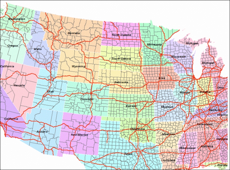
The export operation in the ArcGIS REST API can be used to export an image file from a map service. If you examine http://sampleserver1.arcgisonline.com/ArcGIS/rest/services/Specialty/ESRI_StateCityHighway_USA/MapServer/export, which we used to generate the map image in this recipe, you'll see the term export at the end of the URL. This is what triggers the execution of the export operation. In addition to this, we also appended a bounding box (map extent), size, spatial reference for the image, and format through the payload variable. The request is sent to the server through the requests.get() method which accepts both the URL and payload variable.